Putineiu geodata
Putineiu (Teleorman) is a seat of a second-order administrative division; located in Romania in Europe/Bucharest (GMT+3) time zone. With population of 2,822 people, there are 1893 cities with bigger population in this country. Compared to other cities in Romania, 98.5% of cities are located further ↑North; 53.1% of cities are located further →East and 87.4% of cities have higher elevation than Putineiu. Note1


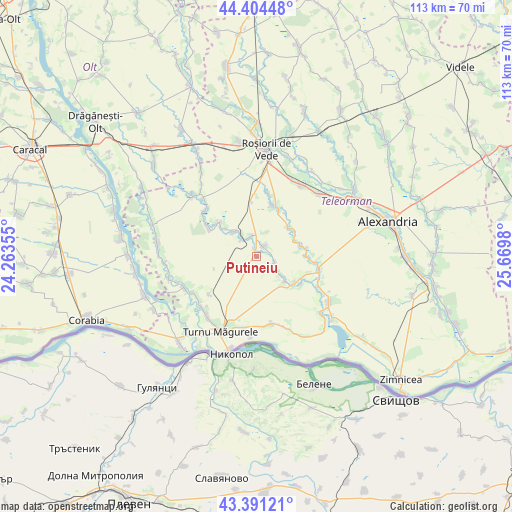
Putineiu GPS coordinates[2]
43° 54' 0" North, 24° 58' 0.012" East
| Map corner | latitude | longitude |
|---|---|---|
| Upper-left | 44.40448°, | 24.26355° |
| Center: | 43.9°, | 24.96667° |
| Lower-right: | 43.39121°, | 25.6698° |
| Map W x H: | 112.7×112.7 km | = 70×70mi |
| max Lat: | 48.23793° ⇑98.5% North |
| Putineiu: | 43.9° |
| min Lat: | ⇓1.5% South 43.65638° |
| min Long | Putineiu | max Long |
| 20.31667° | 24.96667° | 29.65403° |
| W 46.9%⇐ | ⇒53.1% E |
Elevation
Elevation of Putineiu is 70 m = 230 ft, and this is 184.9 m = 607 ft below average elevation for this country.
| Max E: |
1278 m = 4193 ft | 87.4% |
| Avg. | 254.9 m = 836 ft | |
| Putineiu | 70 m = 230 ft | |
Min E: |
-2 m = -7 ft | 12.6% |
See also: Romania elevation on elevation.city.
Geographical zone
Putineiu is located in North temperate zone (between Tropic of Cancer and the Arctic Circle). Distance of this Northern Tropic circle is 2275.3 km =1413.8 mi to South.| Distance of | km | miles | from Putineiu |
|---|---|---|---|
| North Pole | 5125.8 | 3185 | to North |
| Arctic Circle | 2520 | 1565.9 | to North |
| Tropic Cancer | 2275.3 | 1413.8 | to South |
| Equator | 4881.2 | 3033 | to South |


Nearby cities:
15 places around Putineiu: (largest is in red/bold)
• Bogdana
10.1 km =6.3 mi,  68°
68°
• Băduleasa
2.8 km =1.7 mi,  26°
26°
• Băneasa
4.6 km =2.9 mi,  343°
343°
• Caravaneți
9.5 km =5.9 mi,  310°
310°
• Crângu
10.5 km =6.5 mi,  124°
124°
• Cârlomanu
1.9 km =1.2 mi, 343°
• Călmăţuiu
10.9 km =6.8 mi, 312°
• Dracea
8.9 km =5.5 mi,  129°
129°
• Nicolae Bălcescu
12.8 km =8 mi,  301°
301°
• Salcia
6.9 km =4.3 mi,  324°
324°
• Secara
11.6 km =7.2 mi, 122°
• Troianul
11.4 km =7.1 mi,  13°
13°
• Tudor Vladimirescu
7.2 km =4.5 mi, 317°
• Ulmeni
10.9 km =6.8 mi,  88°
88°
• Urluiu
9.3 km =5.8 mi,  48°
48°
Sources, notices
• [Note1] Compared only with cities in Romania existing in our database
• [Src1] Map data: © OpenStreetMap contributors (CC-BY-SA)
• [Src2] Other city data from geonames.org with taken over terms of usage.
• [Src3] Geographical zone / Annual Mean Temperature by Robert A. Rohde @ Wikipedia
