Pustiana geodata
Pustiana (Bacău) is a populated place; located in Romania in Europe/Bucharest (GMT+3) time zone. With population of 2,070 people, there are 2539 cities with bigger population in this country. Compared to other cities in Romania, 69.2% of cities are located further ↓South; 75.1% of cities are located further ←West and 76.3% of cities have lower elevation than Pustiana. Note1


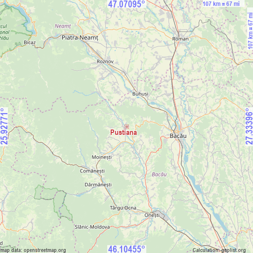
Pustiana GPS coordinates[2]
46° 35' 23.64" North, 26° 37' 50.988" East
| Map corner | latitude | longitude |
|---|---|---|
| Upper-left | 47.07095°, | 25.92771° |
| Center: | 46.5899°, | 26.63083° |
| Lower-right: | 46.10455°, | 27.33396° |
| Map W x H: | 107.5×107.5 km | = 66.8×66.8mi |
| max Lat: | 48.23793° ⇑30.8% North |
| Pustiana: | 46.5899° |
| min Lat: | ⇓69.2% South 43.65638° |
| min Long | Pustiana | max Long |
| 20.31667° | 26.63083° | 29.65403° |
| W 75.1%⇐ | ⇒24.9% E |
Elevation
Elevation of Pustiana is 363 m = 1191 ft, and this is 108.1 m = 355 ft above average elevation for this country.
| Max E: |
1278 m = 4193 ft | 23.7% |
| Pustiana | 363 m 1191 ft | |
| Avg. | 254.9 m = 836 ft | |
Min E: |
-2 m = -7 ft | 76.3% |
See also: Romania elevation on elevation.city.
Geographical zone
Pustiana is located in North temperate zone (between Tropic of Cancer and the Arctic Circle). Distance of this North polar circle is 2220.9 km =1380 mi to North.| Distance of | km | miles | from Pustiana |
|---|---|---|---|
| North Pole | 4826.8 | 2999.2 | to North |
| Arctic Circle | 2220.9 | 1380 | to North |
| Tropic Cancer | 2574.4 | 1599.7 | to South |
| Equator | 5180.3 | 3218.9 | to South |


Nearby cities:
15 places around Pustiana: (largest is in red/bold)
• Ardeoani
6.7 km =4.2 mi,  200°
200°
• Balcani
7.8 km =4.8 mi,  308°
308°
• Băhnășeni
4.2 km =2.6 mi,  242°
242°
• Băsăști
4.5 km =2.8 mi,  330°
330°
• Cucuieți
7.8 km =4.8 mi,  269°
269°
• Câmpeni
1.2 km =0.7 mi,  347°
347°
• Florești
7.8 km =4.8 mi,  159°
159°
• Grigoreni
4 km =2.5 mi,  79°
79°
• Leontinești
8.6 km =5.3 mi, 199°
• Ludași
5.1 km =3.2 mi, 309°
• Pârjol
2.5 km =1.6 mi,  252°
252°
• Scorţeni
4.7 km =2.9 mi, 161°
• Strugari
9.1 km =5.7 mi,  133°
133°
• Sărata
6.5 km =4 mi, 246°
• Tescani
8.9 km =5.5 mi,  167°
167°
Sources, notices
• [Note1] Compared only with cities in Romania existing in our database
• [Src1] Map data: © OpenStreetMap contributors (CC-BY-SA)
• [Src2] Other city data from geonames.org with taken over terms of usage.
• [Src3] Geographical zone / Annual Mean Temperature by Robert A. Rohde @ Wikipedia
