Câmpeni geodata
Câmpeni (Bacău) is a populated place; located in Romania in Europe/Bucharest (GMT+3) time zone. With population of 663 people, there are 5791 cities with bigger population in this country. Compared to other cities in Romania, 69.5% of cities are located further ↓South; 75% of cities are located further ←West and 72.5% of cities have lower elevation than Câmpeni. Note1


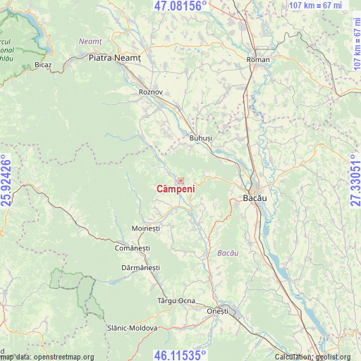
Câmpeni GPS coordinates[2]
46° 36' 2.196" North, 26° 37' 38.568" East
| Map corner | latitude | longitude |
|---|---|---|
| Upper-left | 47.08156°, | 25.92426° |
| Center: | 46.60061°, | 26.62738° |
| Lower-right: | 46.11535°, | 27.33051° |
| Map W x H: | 107.4×107.4 km | = 66.7×66.7mi |
| max Lat: | 48.23793° ⇑30.5% North |
| Câmpeni: | 46.60061° |
| min Lat: | ⇓69.5% South 43.65638° |
| min Long | Câmpeni | max Long |
| 20.31667° | 26.62738° | 29.65403° |
| W 75%⇐ | ⇒25% E |
Elevation
Elevation of Câmpeni is 337 m = 1106 ft, and this is 82.1 m = 269 ft above average elevation for this country.
| Max E: |
1278 m = 4193 ft | 27.5% |
| Câmpeni | 337 m 1106 ft | |
| Avg. | 254.9 m = 836 ft | |
Min E: |
-2 m = -7 ft | 72.5% |
See also: Romania elevation on elevation.city.
Geographical zone
Câmpeni is located in North temperate zone (between Tropic of Cancer and the Arctic Circle). Distance of this North polar circle is 2219.7 km =1379.3 mi to North.| Distance of | km | miles | from Câmpeni |
|---|---|---|---|
| North Pole | 4825.6 | 2998.5 | to North |
| Arctic Circle | 2219.7 | 1379.3 | to North |
| Tropic Cancer | 2575.6 | 1600.4 | to South |
| Equator | 5181.5 | 3219.6 | to South |


Nearby cities:
15 places around Câmpeni: (largest is in red/bold)
• Ardeoani
7.8 km =4.8 mi,  195°
195°
• Balcani
6.9 km =4.3 mi,  301°
301°
• Blăgeşti
9.4 km =5.8 mi,  10°
10°
• Băhnășeni
4.7 km =2.9 mi,  228°
228°
• Băsăști
3.3 km =2.1 mi,  323°
323°
• Cucuieți
7.6 km =4.7 mi,  260°
260°
• Florești
9 km =5.6 mi,  160°
160°
• Frumoasa
9.5 km =5.9 mi, 316°
• Grigoreni
4.2 km =2.6 mi,  96°
96°
• Leontinești
9.7 km =6 mi, 195°
• Ludași
4.2 km =2.6 mi, 299°
• Pustiana
1.2 km =0.7 mi,  167°
167°
• Pârjol
2.8 km =1.7 mi, 227°
• Scorţeni
5.9 km =3.7 mi, 162°
• Sărata
6.8 km =4.2 mi,  236°
236°
Sources, notices
• [Note1] Compared only with cities in Romania existing in our database
• [Src1] Map data: © OpenStreetMap contributors (CC-BY-SA)
• [Src2] Other city data from geonames.org with taken over terms of usage.
• [Src3] Geographical zone / Annual Mean Temperature by Robert A. Rohde @ Wikipedia
