Pristol geodata
Pristol (Mehedinţi) is a seat of a second-order administrative division; located in Romania in Europe/Bucharest (GMT+3) time zone. With population of 1,774 people, there are 2841 cities with bigger population in this country. Compared to other cities in Romania, 92.8% of cities are located further ↑North; 88.1% of cities are located further →East and 93.2% of cities have higher elevation than Pristol. Note1


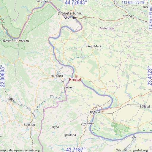
Pristol GPS coordinates[2]
44° 13' 28.992" North, 22° 42' 33.012" East
| Map corner | latitude | longitude |
|---|---|---|
| Upper-left | 44.72643°, | 22.00605° |
| Center: | 44.22472°, | 22.70917° |
| Lower-right: | 43.7187°, | 23.4123° |
| Map W x H: | 112×112 km | = 69.6×69.6mi |
| max Lat: | 48.23793° ⇑92.8% North |
| Pristol: | 44.22472° |
| min Lat: | ⇓7.2% South 43.65638° |
| min Long | Pristol | max Long |
| 20.31667° | 22.70917° | 29.65403° |
| W 11.9%⇐ | ⇒88.1% E |
Elevation
Elevation of Pristol is 42 m = 138 ft, and this is 212.9 m = 698 ft below average elevation for this country.
| Max E: |
1278 m = 4193 ft | 93.2% |
| Avg. | 254.9 m = 836 ft | |
| Pristol | 42 m = 138 ft | |
Min E: |
-2 m = -7 ft | 6.8% |
See also: Romania elevation on elevation.city.
Geographical zone
Pristol is located in North temperate zone (between Tropic of Cancer and the Arctic Circle). Distance of this Northern Tropic circle is 2311.4 km =1436.2 mi to South.| Distance of | km | miles | from Pristol |
|---|---|---|---|
| North Pole | 5089.7 | 3162.6 | to North |
| Arctic Circle | 2483.8 | 1543.4 | to North |
| Tropic Cancer | 2311.4 | 1436.2 | to South |
| Equator | 4917.3 | 3055.5 | to South |


Nearby cities:
15 places around Pristol: (largest is in red/bold)
• Aurora
18.7 km =11.6 mi,  100°
100°
• Balta Verde
15.9 km =9.9 mi,  326°
326°
• Cioroboreni
18.7 km =11.6 mi,  13°
13°
• Cozia
1.1 km =0.7 mi,  161°
161°
• Cujmir
17.4 km =10.8 mi, 96°
• Cujmiru Mic
17.7 km =11 mi, 102°
• Dănceu
15.5 km =9.6 mi,  3°
3°
• Gruia
4.8 km =3 mi,  355°
355°
• Gârla-Mare
5.5 km =3.4 mi,  108°
108°
• Izvoarele
10.1 km =6.3 mi,  338°
338°
• Pătulele
14.3 km =8.9 mi,  20°
20°
• Roșiori
17.8 km =11.1 mi,  78°
78°
• Viașu
17.1 km =10.6 mi,  32°
32°
• Vrata
11.7 km =7.3 mi, 108°
• Vânători
17.6 km =10.9 mi, 83°
Sources, notices
• [Note1] Compared only with cities in Romania existing in our database
• [Src1] Map data: © OpenStreetMap contributors (CC-BY-SA)
• [Src2] Other city data from geonames.org with taken over terms of usage.
• [Src3] Geographical zone / Annual Mean Temperature by Robert A. Rohde @ Wikipedia
