Pătulele geodata
Pătulele (Mehedinţi) is a seat of a second-order administrative division; located in Romania in Europe/Bucharest (GMT+3) time zone. With population of 4,395 people, there are 998 cities with bigger population in this country. Compared to other cities in Romania, 89.8% of cities are located further ↑North; 87.5% of cities are located further →East and 86.1% of cities have higher elevation than Pătulele. Note1


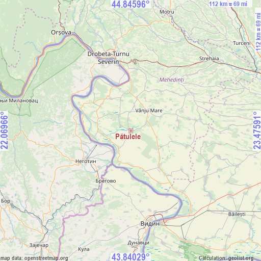
Pătulele GPS coordinates[2]
44° 20' 43.008" North, 22° 46' 22.008" East
| Map corner | latitude | longitude |
|---|---|---|
| Upper-left | 44.84596°, | 22.06966° |
| Center: | 44.34528°, | 22.77278° |
| Lower-right: | 43.84029°, | 23.47591° |
| Map W x H: | 111.8×111.8 km | = 69.5×69.5mi |
| max Lat: | 48.23793° ⇑89.8% North |
| Pătulele: | 44.34528° |
| min Lat: | ⇓10.2% South 43.65638° |
| min Long | Pătulele | max Long |
| 20.31667° | 22.77278° | 29.65403° |
| W 12.5%⇐ | ⇒87.5% E |
Elevation
Elevation of Pătulele is 75 m = 246 ft, and this is 179.9 m = 590 ft below average elevation for this country.
| Max E: |
1278 m = 4193 ft | 86.1% |
| Avg. | 254.9 m = 836 ft | |
| Pătulele | 75 m = 246 ft | |
Min E: |
-2 m = -7 ft | 13.9% |
See also: Romania elevation on elevation.city.
Geographical zone
Pătulele is located in North temperate zone (between Tropic of Cancer and the Arctic Circle). Distance of this Northern Tropic circle is 2324.8 km =1444.6 mi to South.| Distance of | km | miles | from Pătulele |
|---|---|---|---|
| North Pole | 5076.3 | 3154.3 | to North |
| Arctic Circle | 2470.4 | 1535 | to North |
| Tropic Cancer | 2324.8 | 1444.6 | to South |
| Equator | 4930.7 | 3063.8 | to South |


Nearby cities:
15 places around Pătulele: (largest is in red/bold)
• Balta Verde
13.8 km =8.6 mi,  269°
269°
• Cioroboreni
4.9 km =3 mi,  351°
351°
• Dănceu
4.6 km =2.9 mi,  297°
297°
• Gruia
10.2 km =6.3 mi,  212°
212°
• Izvoarele
9.6 km =6 mi,  245°
245°
• Jiana
7.9 km =4.9 mi,  322°
322°
• Jiana Mare
9.9 km =6.2 mi, 317°
• Jiana Veche
9.7 km =6 mi, 301°
• Nicolae Bălcescu
7.5 km =4.7 mi,  64°
64°
• Recea
11.8 km =7.3 mi,  104°
104°
• Scăpău
13.8 km =8.6 mi,  343°
343°
• Valea Anilor
12.1 km =7.5 mi,  79°
79°
• Viașu
4.3 km =2.7 mi, 76°
• Vânju-Mare
11.8 km =7.3 mi,  40°
40°
• Vânjuleţ
10.8 km =6.7 mi,  8°
8°
Sources, notices
• [Note1] Compared only with cities in Romania existing in our database
• [Src1] Map data: © OpenStreetMap contributors (CC-BY-SA)
• [Src2] Other city data from geonames.org with taken over terms of usage.
• [Src3] Geographical zone / Annual Mean Temperature by Robert A. Rohde @ Wikipedia
