Gruia geodata
Gruia (Mehedinţi) is a seat of a second-order administrative division; located in Romania in Europe/Bucharest (GMT+3) time zone. With population of 3,126 people, there are 1672 cities with bigger population in this country. Compared to other cities in Romania, 91.6% of cities are located further ↑North; 88.1% of cities are located further →East and 79% of cities have higher elevation than Gruia. Note1


Gruia GPS coordinates[2]
44° 16' 3" North, 22° 42' 16.992" East
| Map corner | latitude | longitude |
|---|---|---|
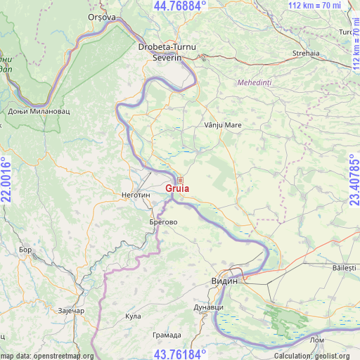
| Upper-left | 44.76884°, | 22.0016° |
| Center: | 44.2675°, | 22.70472° |
| Lower-right: | 43.76184°, | 23.40785° |
| Map W x H: | 112×112 km | = 69.6×69.6mi |
| max Lat: | 48.23793° ⇑91.6% North |
| Gruia: | 44.2675° |
| min Lat: | ⇓8.4% South 43.65638° |
| min Long | Gruia | max Long |
| 20.31667° | 22.70472° | 29.65403° |
| W 11.9%⇐ | ⇒88.1% E |
Elevation
Elevation of Gruia is 98 m = 322 ft, and this is 156.9 m = 515 ft below average elevation for this country.
| Max E: |
1278 m = 4193 ft | 79% |
| Avg. | 254.9 m = 836 ft | |
| Gruia | 98 m = 322 ft | |
Min E: |
-2 m = -7 ft | 21% |
See also: Romania elevation on elevation.city.
Geographical zone
Gruia is located in North temperate zone (between Tropic of Cancer and the Arctic Circle). Distance of this Northern Tropic circle is 2316.2 km =1439.2 mi to South.| Distance of | km | miles | from Gruia |
|---|---|---|---|
| North Pole | 5085 | 3159.7 | to North |
| Arctic Circle | 2479.1 | 1540.4 | to North |
| Tropic Cancer | 2316.2 | 1439.2 | to South |
| Equator | 4922.1 | 3058.5 | to South |


Nearby cities:
15 places around Gruia: (largest is in red/bold)
• Balta Verde
12 km =7.5 mi,  315°
315°
• Cioroboreni
14.3 km =8.9 mi,  19°
19°
• Cozia
5.9 km =3.7 mi,  173°
173°
• Dănceu
10.8 km =6.7 mi,  6°
6°
• Gogoşu
14.8 km =9.2 mi, 323°
• Gârla-Mare
8.6 km =5.3 mi,  139°
139°
• Izvoarele
5.7 km =3.5 mi, 324°
• Jiana
15 km =9.3 mi,  2°
2°
• Jiana Mare
16 km =9.9 mi,  355°
355°
• Jiana Veche
14 km =8.7 mi,  348°
348°
• Nicolae Bălcescu
17 km =10.6 mi,  45°
45°
• Pristol
4.8 km =3 mi,  175°
175°
• Pătulele
10.2 km =6.3 mi,  32°
32°
• Viașu
13.6 km =8.5 mi,  44°
44°
• Vrata
14.3 km =8.9 mi,  126°
126°
Sources, notices
• [Note1] Compared only with cities in Romania existing in our database
• [Src1] Map data: © OpenStreetMap contributors (CC-BY-SA)
• [Src2] Other city data from geonames.org with taken over terms of usage.
• [Src3] Geographical zone / Annual Mean Temperature by Robert A. Rohde @ Wikipedia
