Budila geodata
Budila (Braşov) is a seat of a second-order administrative division; located in Romania in Europe/Bucharest (GMT+3) time zone. With population of 3,405 people, there are 1488 cities with bigger population in this country. Compared to other cities in Romania, 52.5% of cities are located further ↑North; 59.1% of cities are located further ←West and 92.8% of cities have lower elevation than Budila. Note1


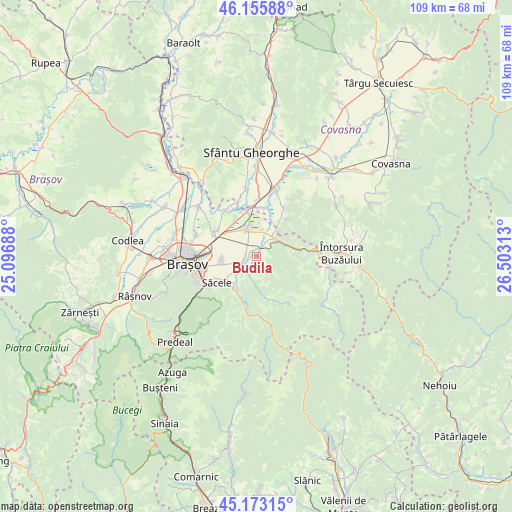
Budila GPS coordinates[2]
45° 40' 0.012" North, 25° 48' 0" East
| Map corner | latitude | longitude |
|---|---|---|
| Upper-left | 46.15588°, | 25.09688° |
| Center: | 45.66667°, | 25.8° |
| Lower-right: | 45.17315°, | 26.50313° |
| Map W x H: | 109.3×109.3 km | = 67.9×67.9mi |
| max Lat: | 48.23793° ⇑52.5% North |
| Budila: | 45.66667° |
| min Lat: | ⇓47.5% South 43.65638° |
| min Long | Budila | max Long |
| 20.31667° | 25.8° | 29.65403° |
| W 59.1%⇐ | ⇒40.9% E |
Elevation
Elevation of Budila is 564 m = 1850 ft, and this is 309.1 m = 1014 ft above average elevation for this country.
| Max E: |
1278 m = 4193 ft | 7.2% |
| Budila | 564 m 1850 ft | |
| Avg. | 254.9 m = 836 ft | |
Min E: |
-2 m = -7 ft | 92.8% |
See also: Romania elevation on elevation.city.
Geographical zone
Budila is located in North temperate zone (between Tropic of Cancer and the Arctic Circle). Distance of this North polar circle is 2323.5 km =1443.8 mi to North.| Distance of | km | miles | from Budila |
|---|---|---|---|
| North Pole | 4929.4 | 3063 | to North |
| Arctic Circle | 2323.5 | 1443.8 | to North |
| Tropic Cancer | 2471.7 | 1535.8 | to South |
| Equator | 5077.7 | 3155.1 | to South |


Nearby cities:
15 places around Budila: (largest is in red/bold)
• Chichiş
13 km =8.1 mi,  0°
0°
• Dobolii de Jos
13.3 km =8.3 mi,  345°
345°
• Dobârlău
9.8 km =6.1 mi,  41°
41°
• Dălghiu
13.7 km =8.5 mi,  140°
140°
• Hărman
10.6 km =6.6 mi,  301°
301°
• Ilieni
15 km =9.3 mi, 350°
• Podu Oltului
12 km =7.5 mi,  330°
330°
• Prejmer
6.1 km =3.8 mi,  335°
335°
• Purcăreni
2.5 km =1.6 mi,  195°
195°
• Sânpetru
13.6 km =8.5 mi,  291°
291°
• Săcele
8.9 km =5.5 mi,  231°
231°
• Teliu
5.6 km =3.5 mi,  50°
50°
• Tunelu-Teliu
5.4 km =3.4 mi, 46°
• Tărlungeni
5.4 km =3.4 mi, 226°
• Zizin
3.7 km =2.3 mi,  206°
206°
Sources, notices
• [Note1] Compared only with cities in Romania existing in our database
• [Src1] Map data: © OpenStreetMap contributors (CC-BY-SA)
• [Src2] Other city data from geonames.org with taken over terms of usage.
• [Src3] Geographical zone / Annual Mean Temperature by Robert A. Rohde @ Wikipedia
