Pleșani geodata
Pleșani (Botoşani) is a populated place; located in Romania in Europe/Bucharest (GMT+3) time zone. With population of 615 people, there are 6102 cities with bigger population in this country. Compared to other cities in Romania, 92.8% of cities are located further ↓South; 88.1% of cities are located further ←West and 78.4% of cities have higher elevation than Pleșani. Note1


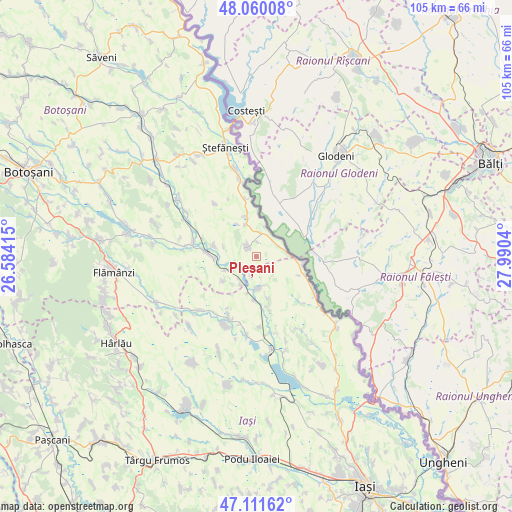
Pleșani GPS coordinates[2]
47° 35' 16.8" North, 27° 17' 14.172" East
| Map corner | latitude | longitude |
|---|---|---|
| Upper-left | 48.06008°, | 26.58415° |
| Center: | 47.588°, | 27.28727° |
| Lower-right: | 47.11162°, | 27.9904° |
| Map W x H: | 105.5×105.5 km | = 65.6×65.6mi |
| max Lat: | 48.23793° ⇑7.2% North |
| Pleșani: | 47.588° |
| min Lat: | ⇓92.8% South 43.65638° |
| min Long | Pleșani | max Long |
| 20.31667° | 27.28727° | 29.65403° |
| W 88.1%⇐ | ⇒11.9% E |
Elevation
Elevation of Pleșani is 100 m = 328 ft, and this is 154.9 m = 508 ft below average elevation for this country.
| Max E: |
1278 m = 4193 ft | 78.4% |
| Avg. | 254.9 m = 836 ft | |
| Pleșani | 100 m = 328 ft | |
Min E: |
-2 m = -7 ft | 21.6% |
See also: Romania elevation on elevation.city.
Geographical zone
Pleșani is located in North temperate zone (between Tropic of Cancer and the Arctic Circle). Distance of this North polar circle is 2109.9 km =1311 mi to North.| Distance of | km | miles | from Pleșani |
|---|---|---|---|
| North Pole | 4715.8 | 2930.3 | to North |
| Arctic Circle | 2109.9 | 1311 | to North |
| Tropic Cancer | 2685.4 | 1668.6 | to South |
| Equator | 5291.3 | 3287.9 | to South |


Nearby cities:
15 places around Pleșani: (largest is in red/bold)
• Andrieşeni
6.1 km =3.8 mi,  182°
182°
• Bivolari
12.5 km =7.8 mi,  119°
119°
• Călăraşi
3.5 km =2.2 mi,  334°
334°
• Doina
8.5 km =5.3 mi,  233°
233°
• Dămideni
12.3 km =7.6 mi,  348°
348°
• Glăvănești
4.1 km =2.5 mi,  197°
197°
• Hlipiceni
10.4 km =6.5 mi,  277°
277°
• Iazu Nou
13.1 km =8.1 mi,  206°
206°
• Libertatea
3.2 km =2 mi,  0°
0°
• Rediu
6.3 km =3.9 mi, 213°
• Răuseni
7 km =4.3 mi,  250°
250°
• Santa Mare
5.7 km =3.5 mi,  55°
55°
• Spineni
11.2 km =7 mi,  167°
167°
• Tabăra
9.5 km =5.9 mi,  99°
99°
• Victoria
9.3 km =5.8 mi,  285°
285°
Sources, notices
• [Note1] Compared only with cities in Romania existing in our database
• [Src1] Map data: © OpenStreetMap contributors (CC-BY-SA)
• [Src2] Other city data from geonames.org with taken over terms of usage.
• [Src3] Geographical zone / Annual Mean Temperature by Robert A. Rohde @ Wikipedia
