Bivolari geodata
Bivolari (Iaşi) is a seat of a second-order administrative division; located in Romania in Europe/Bucharest (GMT+3) time zone. With population of 4,530 people, there are 940 cities with bigger population in this country. Compared to other cities in Romania, 91.5% of cities are located further ↓South; 89.9% of cities are located further ←West and 89.2% of cities have higher elevation than Bivolari. Note1


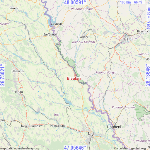
Bivolari GPS coordinates[2]
47° 31' 59.988" North, 27° 25' 59.988" East
| Map corner | latitude | longitude |
|---|---|---|
| Upper-left | 48.00591°, | 26.73021° |
| Center: | 47.53333°, | 27.43333° |
| Lower-right: | 47.05646°, | 28.13646° |
| Map W x H: | 105.6×105.6 km | = 65.6×65.6mi |
| max Lat: | 48.23793° ⇑8.5% North |
| Bivolari: | 47.53333° |
| min Lat: | ⇓91.5% South 43.65638° |
| min Long | Bivolari | max Long |
| 20.31667° | 27.43333° | 29.65403° |
| W 89.9%⇐ | ⇒10.1% E |
Elevation
Elevation of Bivolari is 62 m = 203 ft, and this is 192.9 m = 633 ft below average elevation for this country.
| Max E: |
1278 m = 4193 ft | 89.2% |
| Avg. | 254.9 m = 836 ft | |
| Bivolari | 62 m = 203 ft | |
Min E: |
-2 m = -7 ft | 10.8% |
See also: Romania elevation on elevation.city.
Geographical zone
Bivolari is located in North temperate zone (between Tropic of Cancer and the Arctic Circle). Distance of this North polar circle is 2116 km =1314.8 mi to North.| Distance of | km | miles | from Bivolari |
|---|---|---|---|
| North Pole | 4721.9 | 2934.1 | to North |
| Arctic Circle | 2116 | 1314.8 | to North |
| Tropic Cancer | 2679.3 | 1664.8 | to South |
| Equator | 5285.2 | 3284.1 | to South |


Nearby cities:
15 places around Bivolari: (largest is in red/bold)
• Alexandru cel Bun
13.3 km =8.3 mi,  231°
231°
• Andrieşeni
11.3 km =7 mi,  270°
270°
• Borșa
14 km =8.7 mi,  201°
201°
• Glăvănești
12.4 km =7.7 mi,  279°
279°
• Hermeziu
13.4 km =8.3 mi,  137°
137°
• Libertatea
14.3 km =8.9 mi,  310°
310°
• Pleșani
12.5 km =7.8 mi,  299°
299°
• Rediu
14.4 km =8.9 mi, 273°
• Roșcani
9 km =5.6 mi, 196°
• Rădeni
11.6 km =7.2 mi,  179°
179°
• Santa Mare
11.2 km =7 mi,  325°
325°
• Spineni
9.9 km =6.2 mi,  240°
240°
• Tabăra
4.8 km =3 mi,  340°
340°
• Trifeşti
11.2 km =7 mi,  145°
145°
• Zaboloteni
8 km =5 mi, 142°
Sources, notices
• [Note1] Compared only with cities in Romania existing in our database
• [Src1] Map data: © OpenStreetMap contributors (CC-BY-SA)
• [Src2] Other city data from geonames.org with taken over terms of usage.
• [Src3] Geographical zone / Annual Mean Temperature by Robert A. Rohde @ Wikipedia
