Dămideni geodata
Dămideni (Botoşani) is a populated place; located in Romania in Europe/Bucharest (GMT+3) time zone. With population of 534 people, there are 6736 cities with bigger population in this country. Compared to other cities in Romania, 94.8% of cities are located further ↓South; 87.7% of cities are located further ←West and 72.3% of cities have higher elevation than Dămideni. Note1


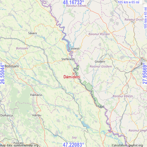
Dămideni GPS coordinates[2]
47° 41' 46.392" North, 27° 15' 12.816" East
| Map corner | latitude | longitude |
|---|---|---|
| Upper-left | 48.16732°, | 26.55044° |
| Center: | 47.69622°, | 27.25356° |
| Lower-right: | 47.22083°, | 27.95669° |
| Map W x H: | 105.2×105.2 km | = 65.4×65.4mi |
| max Lat: | 48.23793° ⇑5.2% North |
| Dămideni: | 47.69622° |
| min Lat: | ⇓94.8% South 43.65638° |
| min Long | Dămideni | max Long |
| 20.31667° | 27.25356° | 29.65403° |
| W 87.7%⇐ | ⇒12.3% E |
Elevation
Elevation of Dămideni is 119 m = 390 ft, and this is 135.9 m = 446 ft below average elevation for this country.
| Max E: |
1278 m = 4193 ft | 72.3% |
| Avg. | 254.9 m = 836 ft | |
| Dămideni | 119 m = 390 ft | |
Min E: |
-2 m = -7 ft | 27.7% |
See also: Romania elevation on elevation.city.
Geographical zone
Dămideni is located in North temperate zone (between Tropic of Cancer and the Arctic Circle). Distance of this North polar circle is 2097.9 km =1303.6 mi to North.| Distance of | km | miles | from Dămideni |
|---|---|---|---|
| North Pole | 4703.7 | 2922.7 | to North |
| Arctic Circle | 2097.9 | 1303.6 | to North |
| Tropic Cancer | 2697.4 | 1676.1 | to South |
| Equator | 5303.3 | 3295.3 | to South |


Nearby cities:
15 places around Dămideni: (largest is in red/bold)
• Bobulești
6.4 km =4 mi,  342°
342°
• Buimăceni
12.5 km =7.8 mi,  257°
257°
• Bădiuți
10.3 km =6.4 mi, 340°
• Cucuteni
12.7 km =7.9 mi,  316°
316°
• Călăraşi
8.9 km =5.5 mi,  173°
173°
• Hlipiceni
13.2 km =8.2 mi,  215°
215°
• Jijia
12.8 km =8 mi,  245°
245°
• Libertatea
9.2 km =5.7 mi,  163°
163°
• Pleșani
12.3 km =7.6 mi, 168°
• Românești
4 km =2.5 mi,  345°
345°
• Santa Mare
11.4 km =7.1 mi,  140°
140°
• Tudor Vladimirescu
6.2 km =3.9 mi, 259°
• Victoria
11.5 km =7.1 mi,  214°
214°
• Ştefăneşti-Sat
11 km =6.8 mi,  331°
331°
• Ștefănești
11.3 km =7 mi, 339°
Sources, notices
• [Note1] Compared only with cities in Romania existing in our database
• [Src1] Map data: © OpenStreetMap contributors (CC-BY-SA)
• [Src2] Other city data from geonames.org with taken over terms of usage.
• [Src3] Geographical zone / Annual Mean Temperature by Robert A. Rohde @ Wikipedia
