Plaiu geodata
Plaiu (Prahova) is a populated place; located in Romania in Europe/Bucharest (GMT+3) time zone. With population of 704 people, there are 5538 cities with bigger population in this country. Compared to other cities in Romania, 61% of cities are located further ↑North; 56% of cities are located further ←West and 97.4% of cities have lower elevation than Plaiu. Note1


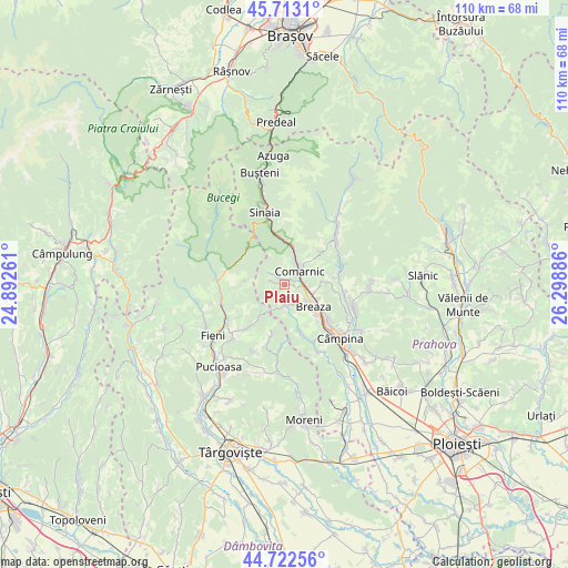
Plaiu GPS coordinates[2]
45° 13' 11.964" North, 25° 35' 44.628" East
| Map corner | latitude | longitude |
|---|---|---|
| Upper-left | 45.7131°, | 24.89261° |
| Center: | 45.21999°, | 25.59573° |
| Lower-right: | 44.72256°, | 26.29886° |
| Map W x H: | 110.1×110.1 km | = 68.4×68.4mi |
| max Lat: | 48.23793° ⇑61% North |
| Plaiu: | 45.21999° |
| min Lat: | ⇓39% South 43.65638° |
| min Long | Plaiu | max Long |
| 20.31667° | 25.59573° | 29.65403° |
| W 56%⇐ | ⇒44% E |
Elevation
Elevation of Plaiu is 737 m = 2418 ft, and this is 482.1 m = 1582 ft above average elevation for this country.
| Max E: |
1278 m = 4193 ft | 2.6% |
| Plaiu | 737 m 2418 ft | |
| Avg. | 254.9 m = 836 ft | |
Min E: |
-2 m = -7 ft | 97.4% |
See also: Romania elevation on elevation.city.
Geographical zone
Plaiu is located in North temperate zone (between Tropic of Cancer and the Arctic Circle). Distance of this North polar circle is 2373.2 km =1474.6 mi to North.| Distance of | km | miles | from Plaiu |
|---|---|---|---|
| North Pole | 4979.1 | 3093.9 | to North |
| Arctic Circle | 2373.2 | 1474.6 | to North |
| Tropic Cancer | 2422.1 | 1505 | to South |
| Equator | 5028 | 3124.3 | to South |


Nearby cities:
15 places around Plaiu: (largest is in red/bold)
• Breaza
6.9 km =4.3 mi,  126°
126°
• Breaza de Sus
5.3 km =3.3 mi,  116°
116°
• Comarnic
4.4 km =2.7 mi,  41°
41°
• Frăsinet
6.9 km =4.3 mi,  113°
113°
• Ghioșești
3.5 km =2.2 mi, 44°
• Gura Beliei
4.3 km =2.7 mi,  103°
103°
• Nistorești
6 km =3.7 mi, 109°
• Ocina de Sus
2.2 km =1.4 mi,  173°
173°
• Podu Lung
4.3 km =2.7 mi,  67°
67°
• Poiana
6 km =3.7 mi,  61°
61°
• Posada
7.7 km =4.8 mi,  13°
13°
• Surdești
4.1 km =2.5 mi,  145°
145°
• Talea
2.5 km =1.6 mi,  284°
284°
• Valea Târsei
5.6 km =3.5 mi, 148°
• Vistieru
8.3 km =5.2 mi,  87°
87°
Sources, notices
• [Note1] Compared only with cities in Romania existing in our database
• [Src1] Map data: © OpenStreetMap contributors (CC-BY-SA)
• [Src2] Other city data from geonames.org with taken over terms of usage.
• [Src3] Geographical zone / Annual Mean Temperature by Robert A. Rohde @ Wikipedia
