Ghioșești geodata
Ghioșești (Prahova) is a populated place; located in Romania in Europe/Bucharest (GMT+3) time zone. With population of 3,484 people, there are 1436 cities with bigger population in this country. Compared to other cities in Romania, 60.5% of cities are located further ↑North; 56.5% of cities are located further ←West and 95.1% of cities have lower elevation than Ghioșești. Note1


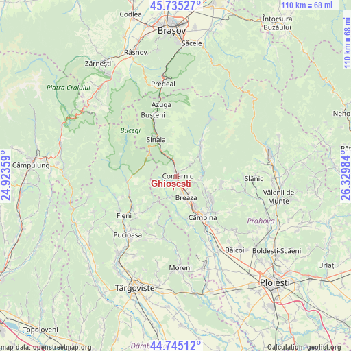
Ghioșești GPS coordinates[2]
45° 14' 32.46" North, 25° 37' 36.156" East
| Map corner | latitude | longitude |
|---|---|---|
| Upper-left | 45.73527°, | 24.92359° |
| Center: | 45.24235°, | 25.62671° |
| Lower-right: | 44.74512°, | 26.32984° |
| Map W x H: | 110.1×110.1 km | = 68.4×68.4mi |
| max Lat: | 48.23793° ⇑60.5% North |
| Ghioșești: | 45.24235° |
| min Lat: | ⇓39.5% South 43.65638° |
| min Long | Ghioșești | max Long |
| 20.31667° | 25.62671° | 29.65403° |
| W 56.5%⇐ | ⇒43.5% E |
Elevation
Elevation of Ghioșești is 630 m = 2067 ft, and this is 375.1 m = 1231 ft above average elevation for this country.
| Max E: |
1278 m = 4193 ft | 4.9% |
| Ghioșești | 630 m 2067 ft | |
| Avg. | 254.9 m = 836 ft | |
Min E: |
-2 m = -7 ft | 95.1% |
See also: Romania elevation on elevation.city.
Geographical zone
Ghioșești is located in North temperate zone (between Tropic of Cancer and the Arctic Circle). Distance of this North polar circle is 2370.7 km =1473.1 mi to North.| Distance of | km | miles | from Ghioșești |
|---|---|---|---|
| North Pole | 4976.6 | 3092.3 | to North |
| Arctic Circle | 2370.7 | 1473.1 | to North |
| Tropic Cancer | 2424.6 | 1506.6 | to South |
| Equator | 5030.5 | 3125.8 | to South |


Nearby cities:
15 places around Ghioșești: (largest is in red/bold)
• Breaza
7.3 km =4.5 mi,  154°
154°
• Breaza de Sus
5.4 km =3.4 mi, 154°
• Comarnic
1 km =0.6 mi,  31°
31°
• Frăsinet
6.5 km =4 mi,  143°
143°
• Gura Beliei
4 km =2.5 mi, 153°
• Nistorești
5.5 km =3.4 mi, 144°
• Ocina de Sus
5.1 km =3.2 mi,  205°
205°
• Plaiu
3.5 km =2.2 mi,  224°
224°
• Podu Lung
1.8 km =1.1 mi,  117°
117°
• Poiana
2.9 km =1.8 mi,  83°
83°
• Posada
5 km =3.1 mi,  352°
352°
• Secăria
6.4 km =4 mi,  44°
44°
• Surdești
5.9 km =3.7 mi,  181°
181°
• Talea
5.2 km =3.2 mi,  249°
249°
• Vistieru
6.3 km =3.9 mi,  110°
110°
Sources, notices
• [Note1] Compared only with cities in Romania existing in our database
• [Src1] Map data: © OpenStreetMap contributors (CC-BY-SA)
• [Src2] Other city data from geonames.org with taken over terms of usage.
• [Src3] Geographical zone / Annual Mean Temperature by Robert A. Rohde @ Wikipedia
