Comarnic geodata
Comarnic (Prahova) is a seat of a second-order administrative division; located in Romania in Europe/Bucharest (GMT+3) time zone. With population of 13,254 people, there are 146 cities with bigger population in this country. Compared to other cities in Romania, 60.3% of cities are located further ↑North; 56.6% of cities are located further ←West and 95.4% of cities have lower elevation than Comarnic. Note1


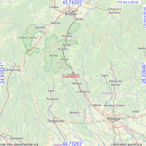
Comarnic GPS coordinates[2]
45° 15' 0" North, 25° 37' 59.988" East
| Map corner | latitude | longitude |
|---|---|---|
| Upper-left | 45.74285°, | 24.93021° |
| Center: | 45.25°, | 25.63333° |
| Lower-right: | 44.75283°, | 26.33646° |
| Map W x H: | 110.1×110.1 km | = 68.4×68.4mi |
| max Lat: | 48.23793° ⇑60.3% North |
| Comarnic: | 45.25° |
| min Lat: | ⇓39.7% South 43.65638° |
| min Long | Comarnic | max Long |
| 20.31667° | 25.63333° | 29.65403° |
| W 56.6%⇐ | ⇒43.4% E |
Elevation
Elevation of Comarnic is 641 m = 2103 ft, and this is 386.1 m = 1267 ft above average elevation for this country.
| Max E: |
1278 m = 4193 ft | 4.6% |
| Comarnic | 641 m 2103 ft | |
| Avg. | 254.9 m = 836 ft | |
Min E: |
-2 m = -7 ft | 95.4% |
See also: Romania elevation on elevation.city.
Geographical zone
Comarnic is located in North temperate zone (between Tropic of Cancer and the Arctic Circle). Distance of this North polar circle is 2369.8 km =1472.5 mi to North.| Distance of | km | miles | from Comarnic |
|---|---|---|---|
| North Pole | 4975.7 | 3091.8 | to North |
| Arctic Circle | 2369.8 | 1472.5 | to North |
| Tropic Cancer | 2425.4 | 1507.1 | to South |
| Equator | 5031.3 | 3126.3 | to South |


Nearby cities:
15 places around Comarnic: (largest is in red/bold)
• Breaza de Sus
6 km =3.7 mi,  162°
162°
• Frăsinet
7 km =4.3 mi,  150°
150°
• Ghioșești
1 km =0.6 mi,  211°
211°
• Gura Beliei
4.6 km =2.9 mi, 163°
• Nistorești
6 km =3.7 mi, 153°
• Ocina de Sus
6.1 km =3.8 mi, 206°
• Plaiu
4.4 km =2.7 mi,  221°
221°
• Podu Lung
2 km =1.2 mi, 147°
• Poiana
2.4 km =1.5 mi,  102°
102°
• Posada
4.3 km =2.7 mi,  344°
344°
• Secăria
5.4 km =3.4 mi,  46°
46°
• Surdești
6.8 km =4.2 mi,  185°
185°
• Talea
6 km =3.7 mi,  243°
243°
• Vistieru
6.1 km =3.8 mi,  119°
119°
• Şotrile
7.5 km =4.7 mi, 119°
Sources, notices
• [Note1] Compared only with cities in Romania existing in our database
• [Src1] Map data: © OpenStreetMap contributors (CC-BY-SA)
• [Src2] Other city data from geonames.org with taken over terms of usage.
• [Src3] Geographical zone / Annual Mean Temperature by Robert A. Rohde @ Wikipedia
