Telciu geodata
Telciu (Bistriţa-Năsăud) is a seat of a second-order administrative division; located in Romania in Europe/Bucharest (GMT+3) time zone. With population of 5,314 people, there are 689 cities with bigger population in this country. Compared to other cities in Romania, 89.5% of cities are located further ↓South; 61.8% of cities are located further →East and 79.9% of cities have lower elevation than Telciu. Note1


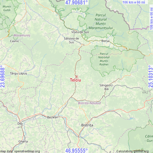
Telciu GPS coordinates[2]
47° 25' 59.988" North, 24° 24' 0" East
| Map corner | latitude | longitude |
|---|---|---|
| Upper-left | 47.90681°, | 23.69688° |
| Center: | 47.43333°, | 24.4° |
| Lower-right: | 46.95555°, | 25.10313° |
| Map W x H: | 105.8×105.8 km | = 65.7×65.7mi |
| max Lat: | 48.23793° ⇑10.5% North |
| Telciu: | 47.43333° |
| min Lat: | ⇓89.5% South 43.65638° |
| min Long | Telciu | max Long |
| 20.31667° | 24.4° | 29.65403° |
| W 38.2%⇐ | ⇒61.8% E |
Elevation
Elevation of Telciu is 393 m = 1289 ft, and this is 138.1 m = 453 ft above average elevation for this country.
| Max E: |
1278 m = 4193 ft | 20.1% |
| Telciu | 393 m 1289 ft | |
| Avg. | 254.9 m = 836 ft | |
Min E: |
-2 m = -7 ft | 79.9% |
See also: Romania elevation on elevation.city.
Geographical zone
Telciu is located in North temperate zone (between Tropic of Cancer and the Arctic Circle). Distance of this North polar circle is 2127.1 km =1321.7 mi to North.| Distance of | km | miles | from Telciu |
|---|---|---|---|
| North Pole | 4733 | 2940.9 | to North |
| Arctic Circle | 2127.1 | 1321.7 | to North |
| Tropic Cancer | 2668.2 | 1657.9 | to South |
| Equator | 5274.1 | 3277.2 | to South |


Nearby cities:
15 places around Telciu: (largest is in red/bold)
• Bichigiu
4.7 km =2.9 mi,  258°
258°
• Coşbuc
7.6 km =4.7 mi,  185°
185°
• Gersa I
11.7 km =7.3 mi,  156°
156°
• Lușca
17.2 km =10.7 mi,  178°
178°
• Năsăud
16.7 km =10.4 mi, 180°
• Parva
11.9 km =7.4 mi,  108°
108°
• Poienile Zagrei
11.9 km =7.4 mi,  244°
244°
• Rebra
15 km =9.3 mi,  149°
149°
• Rebrişoara
17.1 km =10.6 mi,  167°
167°
• Romuli
11.4 km =7.1 mi,  12°
12°
• Runcu Salvei
11.4 km =7.1 mi,  209°
209°
• Salva
15.3 km =9.5 mi, 194°
• Suplai
10.5 km =6.5 mi,  272°
272°
• Telcișor
4.9 km =3 mi,  52°
52°
• Zagra
14.2 km =8.8 mi,  218°
218°
Sources, notices
• [Note1] Compared only with cities in Romania existing in our database
• [Src1] Map data: © OpenStreetMap contributors (CC-BY-SA)
• [Src2] Other city data from geonames.org with taken over terms of usage.
• [Src3] Geographical zone / Annual Mean Temperature by Robert A. Rohde @ Wikipedia
