Nojorid geodata
Nojorid (Bihor) is a seat of a second-order administrative division; located in Romania in Europe/Bucharest (GMT+3) time zone. With population of 4,484 people, there are 960 cities with bigger population in this country. Compared to other cities in Romania, 78.5% of cities are located further ↓South; 95.2% of cities are located further →East and 65.4% of cities have higher elevation than Nojorid. Note1


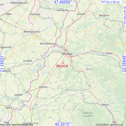
Nojorid GPS coordinates[2]
46° 58' 59.988" North, 21° 52' 59.988" East
| Map corner | latitude | longitude |
|---|---|---|
| Upper-left | 47.46086°, | 21.18021° |
| Center: | 46.98333°, | 21.88333° |
| Lower-right: | 46.5015°, | 22.58646° |
| Map W x H: | 106.7×106.7 km | = 66.3×66.3mi |
| max Lat: | 48.23793° ⇑21.5% North |
| Nojorid: | 46.98333° |
| min Lat: | ⇓78.5% South 43.65638° |
| min Long | Nojorid | max Long |
| 20.31667° | 21.88333° | 29.65403° |
| W 4.8%⇐ | ⇒95.2% E |
Elevation
Elevation of Nojorid is 145 m = 476 ft, and this is 109.9 m = 361 ft below average elevation for this country.
| Max E: |
1278 m = 4193 ft | 65.4% |
| Avg. | 254.9 m = 836 ft | |
| Nojorid | 145 m = 476 ft | |
Min E: |
-2 m = -7 ft | 34.6% |
See also: Romania elevation on elevation.city.
Geographical zone
Nojorid is located in North temperate zone (between Tropic of Cancer and the Arctic Circle). Distance of this North polar circle is 2177.1 km =1352.8 mi to North.| Distance of | km | miles | from Nojorid |
|---|---|---|---|
| North Pole | 4783 | 2972 | to North |
| Arctic Circle | 2177.1 | 1352.8 | to North |
| Tropic Cancer | 2618.1 | 1626.8 | to South |
| Equator | 5224.1 | 3246.1 | to South |


Nearby cities:
15 places around Nojorid: (largest is in red/bold)
• Bicaci
11.6 km =7.2 mi,  218°
218°
• Cheriu
11 km =6.8 mi,  72°
72°
• Cihei
5.5 km =3.4 mi, 72°
• Cordău
8.4 km =5.2 mi,  116°
116°
• Gepiu
9.2 km =5.7 mi,  230°
230°
• Girișu de Criș
12.9 km =8 mi,  314°
314°
• Haieu
8.8 km =5.5 mi,  81°
81°
• Leș
3.9 km =2.4 mi,  238°
238°
• Livada de Bihor
6.4 km =4 mi,  297°
297°
• Mierlău
12.6 km =7.8 mi,  126°
126°
• Oradea
7.4 km =4.6 mi,  20°
20°
• Sititelec
11.9 km =7.4 mi,  173°
173°
• Sânnicolau Român
13 km =8.1 mi,  259°
259°
• Sântandrei
9.5 km =5.9 mi,  346°
346°
• Sînmartin
7.4 km =4.6 mi, 68°
Sources, notices
• [Note1] Compared only with cities in Romania existing in our database
• [Src1] Map data: © OpenStreetMap contributors (CC-BY-SA)
• [Src2] Other city data from geonames.org with taken over terms of usage.
• [Src3] Geographical zone / Annual Mean Temperature by Robert A. Rohde @ Wikipedia
