Movila geodata
Movila (Dâmboviţa) is a populated place; located in Romania in Europe/Bucharest (GMT+3) time zone. With population of 793 people, there are 5086 cities with bigger population in this country. Compared to other cities in Romania, 80.8% of cities are located further ↑North; 62.3% of cities are located further ←West and 78% of cities have higher elevation than Movila. Note1


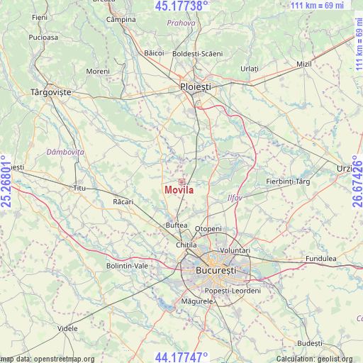
Movila GPS coordinates[2]
44° 40' 46.488" North, 25° 58' 16.068" East
| Map corner | latitude | longitude |
|---|---|---|
| Upper-left | 45.17738°, | 25.26801° |
| Center: | 44.67958°, | 25.97113° |
| Lower-right: | 44.17747°, | 26.67426° |
| Map W x H: | 111.2×111.2 km | = 69.1×69.1mi |
| max Lat: | 48.23793° ⇑80.8% North |
| Movila: | 44.67958° |
| min Lat: | ⇓19.2% South 43.65638° |
| min Long | Movila | max Long |
| 20.31667° | 25.97113° | 29.65403° |
| W 62.3%⇐ | ⇒37.7% E |
Elevation
Elevation of Movila is 101 m = 331 ft, and this is 153.9 m = 505 ft below average elevation for this country.
| Max E: |
1278 m = 4193 ft | 78% |
| Avg. | 254.9 m = 836 ft | |
| Movila | 101 m = 331 ft | |
Min E: |
-2 m = -7 ft | 22% |
See also: Romania elevation on elevation.city.
Geographical zone
Movila is located in North temperate zone (between Tropic of Cancer and the Arctic Circle). Distance of this Northern Tropic circle is 2362 km =1467.7 mi to South.| Distance of | km | miles | from Movila |
|---|---|---|---|
| North Pole | 5039.2 | 3131.2 | to North |
| Arctic Circle | 2433.3 | 1512 | to North |
| Tropic Cancer | 2362 | 1467.7 | to South |
| Equator | 4967.9 | 3086.9 | to South |


Nearby cities:
15 places around Movila: (largest is in red/bold)
• Bujoreanca
8.5 km =5.3 mi,  312°
312°
• Buriaș
6 km =3.7 mi,  7°
7°
• Butimanu
5.6 km =3.5 mi,  274°
274°
• Ciocănari
2.1 km =1.3 mi, 13°
• Cocani
8.3 km =5.2 mi,  226°
226°
• Crevedia
9.3 km =5.8 mi,  198°
198°
• Cătunu
9.5 km =5.9 mi,  316°
316°
• Dârza
8.8 km =5.5 mi,  191°
191°
• Fântânele
9.2 km =5.7 mi,  296°
296°
• Niculești
2.3 km =1.4 mi,  278°
278°
• Ologeni
6.2 km =3.9 mi,  344°
344°
• Periş
3.4 km =2.1 mi,  80°
80°
• Poienarii Burchii
8.6 km =5.3 mi,  24°
24°
• Poienarii-Rali
9.2 km =5.7 mi,  32°
32°
• Tătărăi
7.2 km =4.5 mi,  333°
333°
Sources, notices
• [Note1] Compared only with cities in Romania existing in our database
• [Src1] Map data: © OpenStreetMap contributors (CC-BY-SA)
• [Src2] Other city data from geonames.org with taken over terms of usage.
• [Src3] Geographical zone / Annual Mean Temperature by Robert A. Rohde @ Wikipedia
