Ungureni geodata
Ungureni (Bacău) is a seat of a second-order administrative division; located in Romania in Europe/Bucharest (GMT+3) time zone. With population of 848 people, there are 4853 cities with bigger population in this country. Compared to other cities in Romania, 67.7% of cities are located further ↓South; 85.4% of cities are located further ←West and 52.6% of cities have lower elevation than Ungureni. Note1


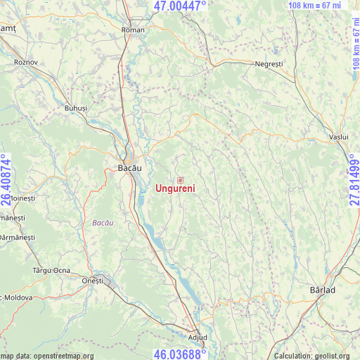
Ungureni GPS coordinates[2]
46° 31' 22.188" North, 27° 6' 42.696" East
| Map corner | latitude | longitude |
|---|---|---|
| Upper-left | 47.00447°, | 26.40874° |
| Center: | 46.52283°, | 27.11186° |
| Lower-right: | 46.03688°, | 27.81499° |
| Map W x H: | 107.6×107.6 km | = 66.9×66.9mi |
| max Lat: | 48.23793° ⇑32.3% North |
| Ungureni: | 46.52283° |
| min Lat: | ⇓67.7% South 43.65638° |
| min Long | Ungureni | max Long |
| 20.31667° | 27.11186° | 29.65403° |
| W 85.4%⇐ | ⇒14.6% E |
Elevation
Elevation of Ungureni is 225 m = 738 ft, and this is 29.9 m = 98 ft below average elevation for this country.
| Max E: |
1278 m = 4193 ft | 47.4% |
| Avg. | 254.9 m = 836 ft | |
| Ungureni | 225 m = 738 ft | |
Min E: |
-2 m = -7 ft | 52.6% |
See also: Romania elevation on elevation.city.
Geographical zone
Ungureni is located in North temperate zone (between Tropic of Cancer and the Arctic Circle). Distance of this North polar circle is 2228.3 km =1384.6 mi to North.| Distance of | km | miles | from Ungureni |
|---|---|---|---|
| North Pole | 4834.2 | 3003.8 | to North |
| Arctic Circle | 2228.3 | 1384.6 | to North |
| Tropic Cancer | 2566.9 | 1595 | to South |
| Equator | 5172.9 | 3214.3 | to South |


Nearby cities:
15 places around Ungureni: (largest is in red/bold)
• Bibirești
2.7 km =1.7 mi,  259°
259°
• Bijghir
11.3 km =7 mi,  320°
320°
• Botești
5.3 km =3.3 mi,  338°
338°
• Buhoci
8.8 km =5.5 mi,  303°
303°
• Chetriș
11.2 km =7 mi,  235°
235°
• Filipeni
5.6 km =3.5 mi,  77°
77°
• Furnicari
8.9 km =5.5 mi, 259°
• Horgeşti
10.5 km =6.5 mi,  199°
199°
• Izvoru Berheciului
10.5 km =6.5 mi,  49°
49°
• Nănești
7.6 km =4.7 mi,  178°
178°
• Parincea
4.5 km =2.8 mi,  191°
191°
• Tamaşi
10.8 km =6.7 mi,  245°
245°
• Tarnița
10.8 km =6.7 mi,  90°
90°
• Vladnic
8.8 km =5.5 mi,  166°
166°
• Văleni
6.8 km =4.2 mi, 202°
Sources, notices
• [Note1] Compared only with cities in Romania existing in our database
• [Src1] Map data: © OpenStreetMap contributors (CC-BY-SA)
• [Src2] Other city data from geonames.org with taken over terms of usage.
• [Src3] Geographical zone / Annual Mean Temperature by Robert A. Rohde @ Wikipedia
