Milcovățu geodata
Milcovățu (Giurgiu) is a populated place; located in Romania in Europe/Bucharest (GMT+3) time zone. With population of 1,405 people, there are 3324 cities with bigger population in this country. Compared to other cities in Romania, 91.7% of cities are located further ↑North; 57.5% of cities are located further ←West and 83.8% of cities have higher elevation than Milcovățu. Note1


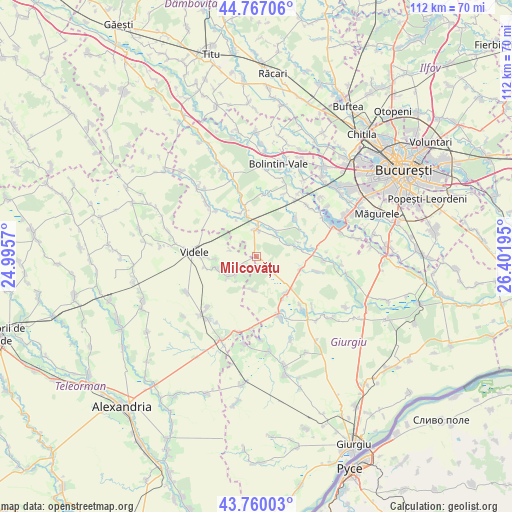
Milcovățu GPS coordinates[2]
44° 15' 56.52" North, 25° 41' 55.752" East
| Map corner | latitude | longitude |
|---|---|---|
| Upper-left | 44.76706°, | 24.9957° |
| Center: | 44.2657°, | 25.69882° |
| Lower-right: | 43.76003°, | 26.40195° |
| Map W x H: | 112×112 km | = 69.6×69.6mi |
| max Lat: | 48.23793° ⇑91.7% North |
| Milcovățu: | 44.2657° |
| min Lat: | ⇓8.3% South 43.65638° |
| min Long | Milcovățu | max Long |
| 20.31667° | 25.69882° | 29.65403° |
| W 57.5%⇐ | ⇒42.5% E |
Elevation
Elevation of Milcovățu is 82 m = 269 ft, and this is 172.9 m = 567 ft below average elevation for this country.
| Max E: |
1278 m = 4193 ft | 83.8% |
| Avg. | 254.9 m = 836 ft | |
| Milcovățu | 82 m = 269 ft | |
Min E: |
-2 m = -7 ft | 16.2% |
See also: Romania elevation on elevation.city.
Geographical zone
Milcovățu is located in North temperate zone (between Tropic of Cancer and the Arctic Circle). Distance of this Northern Tropic circle is 2316 km =1439.1 mi to South.| Distance of | km | miles | from Milcovățu |
|---|---|---|---|
| North Pole | 5085.2 | 3159.8 | to North |
| Arctic Circle | 2479.3 | 1540.6 | to North |
| Tropic Cancer | 2316 | 1439.1 | to South |
| Equator | 4921.9 | 3058.3 | to South |


Nearby cities:
15 places around Milcovățu: (largest is in red/bold)
• Bulbucata
8.5 km =5.3 mi,  76°
76°
• Ciuani
5.3 km =3.3 mi,  227°
227°
• Clejani
6 km =3.7 mi,  0°
0°
• Copaciu
10.9 km =6.8 mi,  148°
148°
• Coșoaia
6 km =3.7 mi,  283°
283°
• Crevenicu
9.2 km =5.7 mi,  252°
252°
• Ghimpați
10.3 km =6.4 mi,  139°
139°
• Letca Nouă
4.9 km =3 mi,  134°
134°
• Letca Veche
7.5 km =4.7 mi,  187°
187°
• Merenii de Jos
5.8 km =3.6 mi, 229°
• Merenii de Sus
7.5 km =4.7 mi,  236°
236°
• Neajlovu
7 km =4.3 mi,  39°
39°
• Podu Doamnei
6 km =3.7 mi, 38°
• Vadu Lat
9 km =5.6 mi,  348°
348°
• Valea Plopilor
10.1 km =6.3 mi,  106°
106°
Sources, notices
• [Note1] Compared only with cities in Romania existing in our database
• [Src1] Map data: © OpenStreetMap contributors (CC-BY-SA)
• [Src2] Other city data from geonames.org with taken over terms of usage.
• [Src3] Geographical zone / Annual Mean Temperature by Robert A. Rohde @ Wikipedia
