Bulbucata geodata
Bulbucata (Giurgiu) is a seat of a second-order administrative division; located in Romania in Europe/Bucharest (GMT+3) time zone. With population of 1,682 people, there are 2944 cities with bigger population in this country. Compared to other cities in Romania, 91.3% of cities are located further ↑North; 59.2% of cities are located further ←West and 87% of cities have higher elevation than Bulbucata. Note1


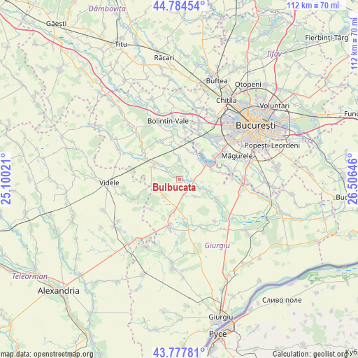
Bulbucata GPS coordinates[2]
44° 16' 59.988" North, 25° 48' 11.988" East
| Map corner | latitude | longitude |
|---|---|---|
| Upper-left | 44.78454°, | 25.10021° |
| Center: | 44.28333°, | 25.80333° |
| Lower-right: | 43.77781°, | 26.50646° |
| Map W x H: | 111.9×111.9 km | = 69.5×69.5mi |
| max Lat: | 48.23793° ⇑91.3% North |
| Bulbucata: | 44.28333° |
| min Lat: | ⇓8.7% South 43.65638° |
| min Long | Bulbucata | max Long |
| 20.31667° | 25.80333° | 29.65403° |
| W 59.2%⇐ | ⇒40.8% E |
Elevation
Elevation of Bulbucata is 71 m = 233 ft, and this is 183.9 m = 603 ft below average elevation for this country.
| Max E: |
1278 m = 4193 ft | 87% |
| Avg. | 254.9 m = 836 ft | |
| Bulbucata | 71 m = 233 ft | |
Min E: |
-2 m = -7 ft | 13% |
See also: Romania elevation on elevation.city.
Geographical zone
Bulbucata is located in North temperate zone (between Tropic of Cancer and the Arctic Circle). Distance of this Northern Tropic circle is 2317.9 km =1440.3 mi to South.| Distance of | km | miles | from Bulbucata |
|---|---|---|---|
| North Pole | 5083.2 | 3158.6 | to North |
| Arctic Circle | 2477.3 | 1539.3 | to North |
| Tropic Cancer | 2317.9 | 1440.3 | to South |
| Equator | 4923.8 | 3059.5 | to South |


Nearby cities:
15 places around Bulbucata: (largest is in red/bold)
• Buturugeni
9.5 km =5.9 mi,  15°
15°
• Clejani
9.2 km =5.7 mi,  296°
296°
• Copaciu
11.6 km =7.2 mi,  193°
193°
• Ghimpați
9.9 km =6.2 mi, 189°
• Gorneni
4.9 km =3 mi,  91°
91°
• Iepureşti
6.9 km =4.3 mi,  114°
114°
• Letca Nouă
7.2 km =4.5 mi,  221°
221°
• Mihăileşti
9.6 km =6 mi,  60°
60°
• Milcovățu
8.5 km =5.3 mi,  256°
256°
• Neajlovu
5.2 km =3.2 mi,  311°
311°
• Podu Doamnei
5.4 km =3.4 mi, 300°
• Pădureni
6.9 km =4.3 mi,  0°
0°
• Stejaru
11 km =6.8 mi, 109°
• Valea Plopilor
5 km =3.1 mi,  164°
164°
• Zorile
10.6 km =6.6 mi, 1°
Sources, notices
• [Note1] Compared only with cities in Romania existing in our database
• [Src1] Map data: © OpenStreetMap contributors (CC-BY-SA)
• [Src2] Other city data from geonames.org with taken over terms of usage.
• [Src3] Geographical zone / Annual Mean Temperature by Robert A. Rohde @ Wikipedia
