Lucăcești geodata
Lucăcești (Maramureş) is a populated place; located in Romania in Europe/Bucharest (GMT+3) time zone. With population of 692 people, there are 5622 cities with bigger population in this country. Compared to other cities in Romania, 91.8% of cities are located further ↓South; 79.4% of cities are located further →East and 62% of cities have higher elevation than Lucăcești. Note1


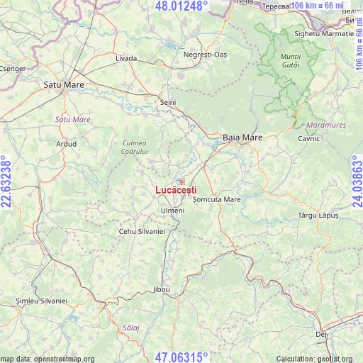
Lucăcești GPS coordinates[2]
47° 32' 23.856" North, 23° 20' 7.8" East
| Map corner | latitude | longitude |
|---|---|---|
| Upper-left | 48.01248°, | 22.63238° |
| Center: | 47.53996°, | 23.3355° |
| Lower-right: | 47.06315°, | 24.03863° |
| Map W x H: | 105.6×105.6 km | = 65.6×65.6mi |
| max Lat: | 48.23793° ⇑8.2% North |
| Lucăcești: | 47.53996° |
| min Lat: | ⇓91.8% South 43.65638° |
| min Long | Lucăcești | max Long |
| 20.31667° | 23.3355° | 29.65403° |
| W 20.6%⇐ | ⇒79.4% E |
Elevation
Elevation of Lucăcești is 159 m = 522 ft, and this is 95.9 m = 315 ft below average elevation for this country.
| Max E: |
1278 m = 4193 ft | 62% |
| Avg. | 254.9 m = 836 ft | |
| Lucăcești | 159 m = 522 ft | |
Min E: |
-2 m = -7 ft | 38% |
See also: Romania elevation on elevation.city.
Geographical zone
Lucăcești is located in North temperate zone (between Tropic of Cancer and the Arctic Circle). Distance of this North polar circle is 2115.2 km =1314.3 mi to North.| Distance of | km | miles | from Lucăcești |
|---|---|---|---|
| North Pole | 4721.1 | 2933.6 | to North |
| Arctic Circle | 2115.2 | 1314.3 | to North |
| Tropic Cancer | 2680 | 1665.3 | to South |
| Equator | 5285.9 | 3284.5 | to South |


Nearby cities:
15 places around Lucăcești: (largest is in red/bold)
• Buzești
7.7 km =4.8 mi,  11°
11°
• Bârsău de Jos
8.2 km =5.1 mi,  318°
318°
• Fersig
3.6 km =2.2 mi,  89°
89°
• Fărcaşa
4.8 km =3 mi,  358°
358°
• Gârdani
2.4 km =1.5 mi,  302°
302°
• Iadăra
8.3 km =5.2 mi,  144°
144°
• Mireşu Mare
4.4 km =2.7 mi,  182°
182°
• Mogoșești
6.6 km =4.1 mi,  45°
45°
• Pribilești
4 km =2.5 mi, 45°
• Remeți pe Someș
6.5 km =4 mi, 177°
• Satulung
7.9 km =4.9 mi,  67°
67°
• Sârbi
6 km =3.7 mi, 5°
• Sălsig
2.8 km =1.7 mi,  254°
254°
• Tulghieș
5.1 km =3.2 mi,  148°
148°
• Tămaia
6.4 km =4 mi,  21°
21°
Sources, notices
• [Note1] Compared only with cities in Romania existing in our database
• [Src1] Map data: © OpenStreetMap contributors (CC-BY-SA)
• [Src2] Other city data from geonames.org with taken over terms of usage.
• [Src3] Geographical zone / Annual Mean Temperature by Robert A. Rohde @ Wikipedia
