Livadia geodata
Livadia (Hunedoara) is a populated place; located in Romania in Europe/Bucharest (GMT+3) time zone. With population of 820 people, there are 4954 cities with bigger population in this country. Compared to other cities in Romania, 55.4% of cities are located further ↑North; 82.7% of cities are located further →East and 84.2% of cities have lower elevation than Livadia. Note1


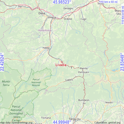
Livadia GPS coordinates[2]
45° 29' 40.236" North, 23° 7' 52.896" East
| Map corner | latitude | longitude |
|---|---|---|
| Upper-left | 45.98523°, | 22.42824° |
| Center: | 45.49451°, | 23.13136° |
| Lower-right: | 44.99948°, | 23.83449° |
| Map W x H: | 109.6×109.6 km | = 68.1×68.1mi |
| max Lat: | 48.23793° ⇑55.4% North |
| Livadia: | 45.49451° |
| min Lat: | ⇓44.6% South 43.65638° |
| min Long | Livadia | max Long |
| 20.31667° | 23.13136° | 29.65403° |
| W 17.3%⇐ | ⇒82.7% E |
Elevation
Elevation of Livadia is 437 m = 1434 ft, and this is 182.1 m = 597 ft above average elevation for this country.
| Max E: |
1278 m = 4193 ft | 15.8% |
| Livadia | 437 m 1434 ft | |
| Avg. | 254.9 m = 836 ft | |
Min E: |
-2 m = -7 ft | 84.2% |
See also: Romania elevation on elevation.city.
Geographical zone
Livadia is located in North temperate zone (between Tropic of Cancer and the Arctic Circle). Distance of this North polar circle is 2342.7 km =1455.7 mi to North.| Distance of | km | miles | from Livadia |
|---|---|---|---|
| North Pole | 4948.5 | 3074.9 | to North |
| Arctic Circle | 2342.7 | 1455.7 | to North |
| Tropic Cancer | 2452.6 | 1524 | to South |
| Equator | 5058.5 | 3143.2 | to South |


Nearby cities:
15 places around Livadia: (largest is in red/bold)
• Aninoasa
17.2 km =10.7 mi,  123°
123°
• Baru
3.5 km =2.2 mi,  135°
135°
• Baru Mic
3.4 km =2.1 mi,  154°
154°
• Bucium-Orlea
16.2 km =10.1 mi,  307°
307°
• Băniţa
11.7 km =7.3 mi, 115°
• Fizești
6.4 km =4 mi,  325°
325°
• Lupeni
17.1 km =10.6 mi, 150°
• Petros
4.6 km =2.9 mi,  113°
113°
• Pui
3.5 km =2.2 mi,  315°
315°
• Subcetate
15.9 km =9.9 mi, 319°
• Sântămăria-Orlea
16.3 km =10.1 mi, 309°
• Sălaşu de Sus
14.3 km =8.9 mi,  279°
279°
• Uricani
17.6 km =10.9 mi,  174°
174°
• Vulcan
16.3 km =10.1 mi, 139°
• Șerel
6.3 km =3.9 mi,  259°
259°
Sources, notices
• [Note1] Compared only with cities in Romania existing in our database
• [Src1] Map data: © OpenStreetMap contributors (CC-BY-SA)
• [Src2] Other city data from geonames.org with taken over terms of usage.
• [Src3] Geographical zone / Annual Mean Temperature by Robert A. Rohde @ Wikipedia
