Pui geodata
Pui (Hunedoara) is a seat of a second-order administrative division; located in Romania in Europe/Bucharest (GMT+3) time zone. With population of 4,680 people, there are 888 cities with bigger population in this country. Compared to other cities in Romania, 54.9% of cities are located further ↑North; 83% of cities are located further →East and 82% of cities have lower elevation than Pui. Note1


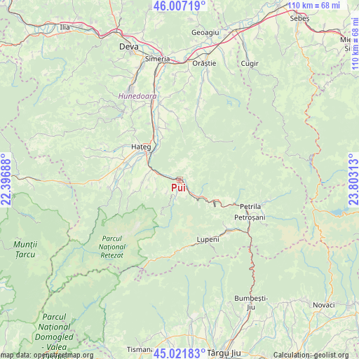
Pui GPS coordinates[2]
45° 31' 0.012" North, 23° 6' 0" East
| Map corner | latitude | longitude |
|---|---|---|
| Upper-left | 46.00719°, | 22.39688° |
| Center: | 45.51667°, | 23.1° |
| Lower-right: | 45.02183°, | 23.80313° |
| Map W x H: | 109.6×109.6 km | = 68.1×68.1mi |
| max Lat: | 48.23793° ⇑54.9% North |
| Pui: | 45.51667° |
| min Lat: | ⇓45.1% South 43.65638° |
| min Long | Pui | max Long |
| 20.31667° | 23.1° | 29.65403° |
| W 17%⇐ | ⇒83% E |
Elevation
Elevation of Pui is 412 m = 1352 ft, and this is 157.1 m = 515 ft above average elevation for this country.
| Max E: |
1278 m = 4193 ft | 18% |
| Pui | 412 m 1352 ft | |
| Avg. | 254.9 m = 836 ft | |
Min E: |
-2 m = -7 ft | 82% |
See also: Romania elevation on elevation.city.
Geographical zone
Pui is located in North temperate zone (between Tropic of Cancer and the Arctic Circle). Distance of this North polar circle is 2340.2 km =1454.1 mi to North.| Distance of | km | miles | from Pui |
|---|---|---|---|
| North Pole | 4946.1 | 3073.4 | to North |
| Arctic Circle | 2340.2 | 1454.1 | to North |
| Tropic Cancer | 2455.1 | 1525.5 | to South |
| Equator | 5061 | 3144.8 | to South |


Nearby cities:
15 places around Pui: (largest is in red/bold)
• Baru
7 km =4.3 mi,  135°
135°
• Baru Mic
6.8 km =4.2 mi, 144°
• Bretea Română
17.3 km =10.7 mi,  338°
338°
• Bucium-Orlea
12.8 km =8 mi,  305°
305°
• Băniţa
15 km =9.3 mi,  119°
119°
• Fizești
3 km =1.9 mi, 337°
• Haţeg
16.1 km =10 mi, 313°
• Livadia
3.5 km =2.2 mi, 135°
• Petros
7.9 km =4.9 mi, 122°
• Păclișa
17.8 km =11.1 mi,  286°
286°
• Subcetate
12.4 km =7.7 mi,  320°
320°
• Sântămăria-Orlea
12.9 km =8 mi, 308°
• Săcel
14.9 km =9.3 mi, 288°
• Sălaşu de Sus
11.7 km =7.3 mi,  270°
270°
• Șerel
5.2 km =3.2 mi,  225°
225°
Sources, notices
• [Note1] Compared only with cities in Romania existing in our database
• [Src1] Map data: © OpenStreetMap contributors (CC-BY-SA)
• [Src2] Other city data from geonames.org with taken over terms of usage.
• [Src3] Geographical zone / Annual Mean Temperature by Robert A. Rohde @ Wikipedia
