Fizești geodata
Fizești (Hunedoara) is a populated place; located in Romania in Europe/Bucharest (GMT+3) time zone. With population of 523 people, there are 6832 cities with bigger population in this country. Compared to other cities in Romania, 54.4% of cities are located further ↑North; 83.2% of cities are located further →East and 87.2% of cities have lower elevation than Fizești. Note1


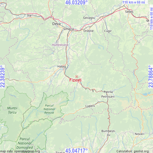
Fizești GPS coordinates[2]
45° 32' 30.444" North, 23° 5' 7.836" East
| Map corner | latitude | longitude |
|---|---|---|
| Upper-left | 46.03209°, | 22.38239° |
| Center: | 45.54179°, | 23.08551° |
| Lower-right: | 45.04717°, | 23.78864° |
| Map W x H: | 109.5×109.5 km | = 68×68mi |
| max Lat: | 48.23793° ⇑54.4% North |
| Fizești: | 45.54179° |
| min Lat: | ⇓45.6% South 43.65638° |
| min Long | Fizești | max Long |
| 20.31667° | 23.08551° | 29.65403° |
| W 16.8%⇐ | ⇒83.2% E |
Elevation
Elevation of Fizești is 472 m = 1549 ft, and this is 217.1 m = 712 ft above average elevation for this country.
| Max E: |
1278 m = 4193 ft | 12.8% |
| Fizești | 472 m 1549 ft | |
| Avg. | 254.9 m = 836 ft | |
Min E: |
-2 m = -7 ft | 87.2% |
See also: Romania elevation on elevation.city.
Geographical zone
Fizești is located in North temperate zone (between Tropic of Cancer and the Arctic Circle). Distance of this North polar circle is 2337.4 km =1452.4 mi to North.| Distance of | km | miles | from Fizești |
|---|---|---|---|
| North Pole | 4943.3 | 3071.6 | to North |
| Arctic Circle | 2337.4 | 1452.4 | to North |
| Tropic Cancer | 2457.9 | 1527.3 | to South |
| Equator | 5063.8 | 3146.5 | to South |


Nearby cities:
15 places around Fizești: (largest is in red/bold)
• Baru
9.8 km =6.1 mi,  142°
142°
• Baru Mic
9.7 km =6 mi,  148°
148°
• Boşorod
15.7 km =9.8 mi,  359°
359°
• Bretea Română
14.3 km =8.9 mi,  338°
338°
• Bucium-Orlea
10.3 km =6.4 mi,  296°
296°
• Haţeg
13.4 km =8.3 mi,  308°
308°
• Livadia
6.4 km =4 mi, 145°
• Petros
10.5 km =6.5 mi,  132°
132°
• Pui
3 km =1.9 mi,  157°
157°
• Subcetate
9.6 km =6 mi, 314°
• Sântămăria-Orlea
10.4 km =6.5 mi, 300°
• Săcel
13.1 km =8.1 mi,  278°
278°
• Sălaşu de Sus
10.9 km =6.8 mi,  255°
255°
• Toteşti
16 km =9.9 mi, 279°
• Șerel
7 km =4.3 mi,  202°
202°
Sources, notices
• [Note1] Compared only with cities in Romania existing in our database
• [Src1] Map data: © OpenStreetMap contributors (CC-BY-SA)
• [Src2] Other city data from geonames.org with taken over terms of usage.
• [Src3] Geographical zone / Annual Mean Temperature by Robert A. Rohde @ Wikipedia
