Întorsura geodata
Întorsura (Dolj) is a seat of a second-order administrative division; located in Romania in Europe/Bucharest (GMT+3) time zone. With population of 1,936 people, there are 2668 cities with bigger population in this country. Compared to other cities in Romania, 95.3% of cities are located further ↑North; 75.9% of cities are located further →East and 84.2% of cities have higher elevation than Întorsura. Note1


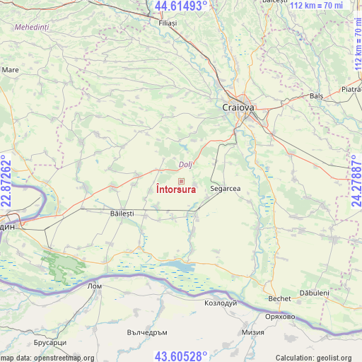
Întorsura GPS coordinates[2]
44° 6' 44.136" North, 23° 34' 32.664" East
| Map corner | latitude | longitude |
|---|---|---|
| Upper-left | 44.61493°, | 22.87262° |
| Center: | 44.11226°, | 23.57574° |
| Lower-right: | 43.60528°, | 24.27887° |
| Map W x H: | 112.3×112.3 km | = 69.8×69.8mi |
| max Lat: | 48.23793° ⇑95.3% North |
| Întorsura: | 44.11226° |
| min Lat: | ⇓4.7% South 43.65638° |
| min Long | Întorsura | max Long |
| 20.31667° | 23.57574° | 29.65403° |
| W 24.1%⇐ | ⇒75.9% E |
Elevation
Elevation of Întorsura is 81 m = 266 ft, and this is 173.9 m = 571 ft below average elevation for this country.
| Max E: |
1278 m = 4193 ft | 84.2% |
| Avg. | 254.9 m = 836 ft | |
| Întorsura | 81 m = 266 ft | |
Min E: |
-2 m = -7 ft | 15.8% |
See also: Romania elevation on elevation.city.
Geographical zone
Întorsura is located in North temperate zone (between Tropic of Cancer and the Arctic Circle). Distance of this Northern Tropic circle is 2298.9 km =1428.5 mi to South.| Distance of | km | miles | from Întorsura |
|---|---|---|---|
| North Pole | 5102.2 | 3170.4 | to North |
| Arctic Circle | 2496.4 | 1551.2 | to North |
| Tropic Cancer | 2298.9 | 1428.5 | to South |
| Equator | 4904.8 | 3047.7 | to South |


Nearby cities:
15 places around Întorsura: (largest is in red/bold)
• Cerăt
8.9 km =5.5 mi,  124°
124°
• Cioroiași
10.5 km =6.5 mi,  252°
252°
• Cioroiu Nou
12.5 km =7.8 mi,  244°
244°
• Curmătura
13.1 km =8.1 mi,  157°
157°
• Giurgiţa
11.6 km =7.2 mi, 156°
• Lipovu
4.8 km =3 mi,  106°
106°
• Mârza
12.1 km =7.5 mi,  320°
320°
• Panaghia
12.3 km =7.6 mi,  56°
56°
• Perișor
8.7 km =5.4 mi,  293°
293°
• Radovan
6.9 km =4.3 mi,  28°
28°
• Siliştea Crucii
11.5 km =7.1 mi,  220°
220°
• Sălcuța
11.4 km =7.1 mi, 62°
• Urzica Mare
10.8 km =6.7 mi,  170°
170°
• Urzicuţa
10.8 km =6.7 mi,  190°
190°
• Vârvor
13.1 km =8.1 mi,  16°
16°
Sources, notices
• [Note1] Compared only with cities in Romania existing in our database
• [Src1] Map data: © OpenStreetMap contributors (CC-BY-SA)
• [Src2] Other city data from geonames.org with taken over terms of usage.
• [Src3] Geographical zone / Annual Mean Temperature by Robert A. Rohde @ Wikipedia
