Ghindăreşti geodata
Ghindăreşti (Constanța) is a seat of a second-order administrative division; located in Romania in Europe/Bucharest (GMT+3) time zone. With population of 2,669 people, there are 2002 cities with bigger population in this country. Compared to other cities in Romania, 81.6% of cities are located further ↑North; 96.5% of cities are located further ←West and 92.4% of cities have higher elevation than Ghindăreşti. Note1


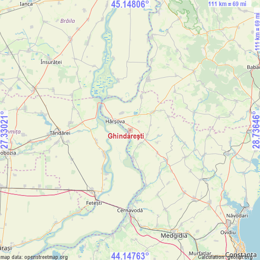
Ghindăreşti GPS coordinates[2]
44° 39' 0" North, 28° 1' 59.988" East
| Map corner | latitude | longitude |
|---|---|---|
| Upper-left | 45.14806°, | 27.33021° |
| Center: | 44.65°, | 28.03333° |
| Lower-right: | 44.14763°, | 28.73646° |
| Map W x H: | 111.2×111.2 km | = 69.1×69.1mi |
| max Lat: | 48.23793° ⇑81.6% North |
| Ghindăreşti: | 44.65° |
| min Lat: | ⇓18.4% South 43.65638° |
| min Long | Ghindăreşti | max Long |
| 20.31667° | 28.03333° | 29.65403° |
| W 96.5%⇐ | ⇒3.5% E |
Elevation
Elevation of Ghindăreşti is 47 m = 154 ft, and this is 207.9 m = 682 ft below average elevation for this country.
| Max E: |
1278 m = 4193 ft | 92.4% |
| Avg. | 254.9 m = 836 ft | |
| Ghindăreşti | 47 m = 154 ft | |
Min E: |
-2 m = -7 ft | 7.6% |
See also: Romania elevation on elevation.city.
Geographical zone
Ghindăreşti is located in North temperate zone (between Tropic of Cancer and the Arctic Circle). Distance of this Northern Tropic circle is 2358.7 km =1465.6 mi to South.| Distance of | km | miles | from Ghindăreşti |
|---|---|---|---|
| North Pole | 5042.4 | 3133.2 | to North |
| Arctic Circle | 2436.6 | 1514 | to North |
| Tropic Cancer | 2358.7 | 1465.6 | to South |
| Equator | 4964.6 | 3084.9 | to South |


Nearby cities:
15 places around Ghindăreşti: (largest is in red/bold)
• Agaua
20.8 km =12.9 mi,  9°
9°
• Ciobanu
8.4 km =5.2 mi,  334°
334°
• Crucea
20.5 km =12.7 mi,  129°
129°
• Făcăeni
14 km =8.7 mi,  228°
228°
• Giurgeni
17.6 km =10.9 mi,  317°
317°
• Gârliciu
13.6 km =8.5 mi,  16°
16°
• Horia
6.8 km =4.2 mi,  105°
105°
• Hârşova
7.7 km =4.8 mi,  300°
300°
• Măgureni
17 km =10.6 mi, 330°
• Progresu
15.2 km =9.4 mi,  239°
239°
• Saraiu
11.8 km =7.3 mi,  51°
51°
• Stupina
15.1 km =9.4 mi, 129°
• Topalu
11.8 km =7.3 mi,  175°
175°
• Vlădeni
12.4 km =7.7 mi,  252°
252°
• Vulturu
18.5 km =11.5 mi,  90°
90°
Sources, notices
• [Note1] Compared only with cities in Romania existing in our database
• [Src1] Map data: © OpenStreetMap contributors (CC-BY-SA)
• [Src2] Other city data from geonames.org with taken over terms of usage.
• [Src3] Geographical zone / Annual Mean Temperature by Robert A. Rohde @ Wikipedia
