Hârseşti geodata
Hârseşti (Arges) is a seat of a second-order administrative division; located in Romania in Europe/Bucharest (GMT+3) time zone. With population of 2,841 people, there are 1882 cities with bigger population in this country. Compared to other cities in Romania, 84.6% of cities are located further ↑North; 55.8% of cities are located further →East and 56.1% of cities have higher elevation than Hârseşti. Note1


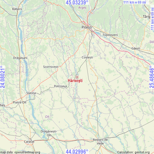
Hârseşti GPS coordinates[2]
44° 31' 59.988" North, 24° 46' 59.988" East
| Map corner | latitude | longitude |
|---|---|---|
| Upper-left | 45.03239°, | 24.08021° |
| Center: | 44.53333°, | 24.78333° |
| Lower-right: | 44.02996°, | 25.48646° |
| Map W x H: | 111.5×111.5 km | = 69.3×69.3mi |
| max Lat: | 48.23793° ⇑84.6% North |
| Hârseşti: | 44.53333° |
| min Lat: | ⇓15.4% South 43.65638° |
| min Long | Hârseşti | max Long |
| 20.31667° | 24.78333° | 29.65403° |
| W 44.2%⇐ | ⇒55.8% E |
Elevation
Elevation of Hârseşti is 182 m = 597 ft, and this is 72.9 m = 239 ft below average elevation for this country.
| Max E: |
1278 m = 4193 ft | 56.1% |
| Avg. | 254.9 m = 836 ft | |
| Hârseşti | 182 m = 597 ft | |
Min E: |
-2 m = -7 ft | 43.9% |
See also: Romania elevation on elevation.city.
Geographical zone
Hârseşti is located in North temperate zone (between Tropic of Cancer and the Arctic Circle). Distance of this Northern Tropic circle is 2345.7 km =1457.5 mi to South.| Distance of | km | miles | from Hârseşti |
|---|---|---|---|
| North Pole | 5055.4 | 3141.3 | to North |
| Arctic Circle | 2449.5 | 1522 | to North |
| Tropic Cancer | 2345.7 | 1457.5 | to South |
| Equator | 4951.6 | 3076.8 | to South |


Nearby cities:
15 places around Hârseşti: (largest is in red/bold)
• Buzoeşti
11.9 km =7.4 mi,  62°
62°
• Bârla
11.9 km =7.4 mi,  182°
182°
• Ciocești
9.6 km =6 mi, 179°
• Cochinești
5.5 km =3.4 mi,  343°
343°
• Colțu
12.5 km =7.8 mi,  110°
110°
• Corbu
7.7 km =4.8 mi,  223°
223°
• Optaşi
11.9 km =7.4 mi,  297°
297°
• Potcoava
11.9 km =7.4 mi,  242°
242°
• Satu Nou
9.8 km =6.1 mi,  123°
123°
• Sinești
11.8 km =7.3 mi,  231°
231°
• Stolnici
3.7 km =2.3 mi,  0°
0°
• Sârbii-Măgura
5.6 km =3.5 mi,  289°
289°
• Urlueni
5.5 km =3.4 mi, 184°
• Valea Merilor
12.2 km =7.6 mi, 235°
• Vitănești
7 km =4.3 mi,  264°
264°
Sources, notices
• [Note1] Compared only with cities in Romania existing in our database
• [Src1] Map data: © OpenStreetMap contributors (CC-BY-SA)
• [Src2] Other city data from geonames.org with taken over terms of usage.
• [Src3] Geographical zone / Annual Mean Temperature by Robert A. Rohde @ Wikipedia
