Buzoeşti geodata
Buzoeşti (Arges) is a seat of a second-order administrative division; located in Romania in Europe/Bucharest (GMT+3) time zone. With population of 6,281 people, there are 495 cities with bigger population in this country. Compared to other cities in Romania, 83.3% of cities are located further ↑North; 53.8% of cities are located further →East and 51.5% of cities have lower elevation than Buzoeşti. Note1


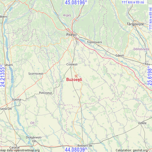
Buzoeşti GPS coordinates[2]
44° 34' 59.988" North, 24° 55' 0.012" East
| Map corner | latitude | longitude |
|---|---|---|
| Upper-left | 45.08196°, | 24.21355° |
| Center: | 44.58333°, | 24.91667° |
| Lower-right: | 44.08039°, | 25.6198° |
| Map W x H: | 111.4×111.4 km | = 69.2×69.2mi |
| max Lat: | 48.23793° ⇑83.3% North |
| Buzoeşti: | 44.58333° |
| min Lat: | ⇓16.7% South 43.65638° |
| min Long | Buzoeşti | max Long |
| 20.31667° | 24.91667° | 29.65403° |
| W 46.2%⇐ | ⇒53.8% E |
Elevation
Elevation of Buzoeşti is 219 m = 719 ft, and this is 35.9 m = 118 ft below average elevation for this country.
| Max E: |
1278 m = 4193 ft | 48.5% |
| Avg. | 254.9 m = 836 ft | |
| Buzoeşti | 219 m = 719 ft | |
Min E: |
-2 m = -7 ft | 51.5% |
See also: Romania elevation on elevation.city.
Geographical zone
Buzoeşti is located in North temperate zone (between Tropic of Cancer and the Arctic Circle). Distance of this Northern Tropic circle is 2351.3 km =1461 mi to South.| Distance of | km | miles | from Buzoeşti |
|---|---|---|---|
| North Pole | 5049.9 | 3137.9 | to North |
| Arctic Circle | 2444 | 1518.6 | to North |
| Tropic Cancer | 2351.3 | 1461 | to South |
| Equator | 4957.2 | 3080.3 | to South |


Nearby cities:
15 places around Buzoeşti: (largest is in red/bold)
• Colțu
10 km =6.2 mi,  173°
173°
• Cornățel
3.1 km =1.9 mi,  97°
97°
• Costeşti
9.6 km =6 mi,  344°
344°
• Deagu de Sus
7.4 km =4.6 mi,  106°
106°
• Gliganu de Sus
10.7 km =6.6 mi,  39°
39°
• Găujani
5.3 km =3.3 mi,  144°
144°
• Humele
8 km =5 mi, 143°
• Hârseşti
11.9 km =7.4 mi,  242°
242°
• Ionești
3.4 km =2.1 mi, 340°
• Recea
9.7 km =6 mi,  125°
125°
• Satu Nou
11.3 km =7 mi,  192°
192°
• Stolnici
10.7 km =6.6 mi,  260°
260°
• Ungheni
10.1 km =6.3 mi,  156°
156°
• Vulpești
2.5 km =1.6 mi,  51°
51°
• Șerboeni
6.4 km =4 mi, 343°
Sources, notices
• [Note1] Compared only with cities in Romania existing in our database
• [Src1] Map data: © OpenStreetMap contributors (CC-BY-SA)
• [Src2] Other city data from geonames.org with taken over terms of usage.
• [Src3] Geographical zone / Annual Mean Temperature by Robert A. Rohde @ Wikipedia
