Cochinești geodata
Cochinești (Arges) is a populated place; located in Romania in Europe/Bucharest (GMT+3) time zone. With population of 691 people, there are 5628 cities with bigger population in this country. Compared to other cities in Romania, 83.3% of cities are located further ↑North; 56.2% of cities are located further →East and 52.8% of cities have higher elevation than Cochinești. Note1


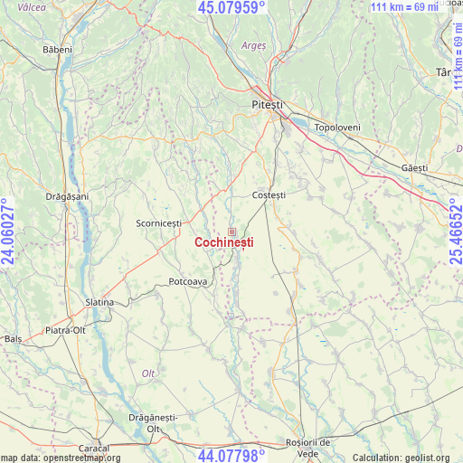
Cochinești GPS coordinates[2]
44° 34' 51.384" North, 24° 45' 48.204" East
| Map corner | latitude | longitude |
|---|---|---|
| Upper-left | 45.07959°, | 24.06027° |
| Center: | 44.58094°, | 24.76339° |
| Lower-right: | 44.07798°, | 25.46652° |
| Map W x H: | 111.4×111.4 km | = 69.2×69.2mi |
| max Lat: | 48.23793° ⇑83.3% North |
| Cochinești: | 44.58094° |
| min Lat: | ⇓16.7% South 43.65638° |
| min Long | Cochinești | max Long |
| 20.31667° | 24.76339° | 29.65403° |
| W 43.8%⇐ | ⇒56.2% E |
Elevation
Elevation of Cochinești is 197 m = 646 ft, and this is 57.9 m = 190 ft below average elevation for this country.
| Max E: |
1278 m = 4193 ft | 52.8% |
| Avg. | 254.9 m = 836 ft | |
| Cochinești | 197 m = 646 ft | |
Min E: |
-2 m = -7 ft | 47.2% |
See also: Romania elevation on elevation.city.
Geographical zone
Cochinești is located in North temperate zone (between Tropic of Cancer and the Arctic Circle). Distance of this Northern Tropic circle is 2351 km =1460.8 mi to South.| Distance of | km | miles | from Cochinești |
|---|---|---|---|
| North Pole | 5050.1 | 3138 | to North |
| Arctic Circle | 2444.2 | 1518.8 | to North |
| Tropic Cancer | 2351 | 1460.8 | to South |
| Equator | 4956.9 | 3080.1 | to South |


Nearby cities:
15 places around Cochinești: (largest is in red/bold)
• Buzoeşti
12.1 km =7.5 mi,  88°
88°
• Coloneşti
10.8 km =6.7 mi,  315°
315°
• Corbu
11.5 km =7.1 mi,  198°
198°
• Costeşti
13.5 km =8.4 mi,  44°
44°
• Hârseşti
5.5 km =3.4 mi,  163°
163°
• Ionești
11.5 km =7.1 mi,  72°
72°
• Lunca Corbului
11.5 km =7.1 mi,  358°
358°
• Negreni
13.4 km =8.3 mi,  264°
264°
• Optaşi
9 km =5.6 mi,  271°
271°
• Stolnici
2.2 km =1.4 mi,  135°
135°
• Sârbii-Măgura
5.1 km =3.2 mi,  227°
227°
• Tătuleşti
11.8 km =7.3 mi,  299°
299°
• Urlueni
10.8 km =6.7 mi,  173°
173°
• Vitănești
8 km =5 mi,  221°
221°
• Șerboeni
12.1 km =7.5 mi,  58°
58°
Sources, notices
• [Note1] Compared only with cities in Romania existing in our database
• [Src1] Map data: © OpenStreetMap contributors (CC-BY-SA)
• [Src2] Other city data from geonames.org with taken over terms of usage.
• [Src3] Geographical zone / Annual Mean Temperature by Robert A. Rohde @ Wikipedia
