Sălcioara geodata
Sălcioara (Dâmboviţa) is a seat of a second-order administrative division; located in Romania in Europe/Bucharest (GMT+3) time zone. With population of 4,125 people, there are 1121 cities with bigger population in this country. Compared to other cities in Romania, 79.7% of cities are located further ↑North; 55.8% of cities are located further ←West and 57.7% of cities have higher elevation than Sălcioara. Note1


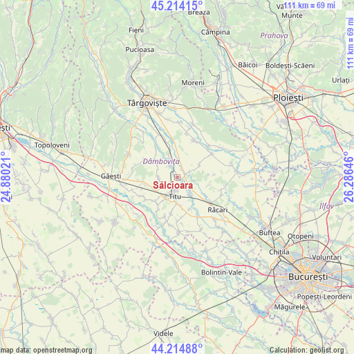
Sălcioara GPS coordinates[2]
44° 43' 0.012" North, 25° 34' 59.988" East
| Map corner | latitude | longitude |
|---|---|---|
| Upper-left | 45.21415°, | 24.88021° |
| Center: | 44.71667°, | 25.58333° |
| Lower-right: | 44.21488°, | 26.28646° |
| Map W x H: | 111.1×111.1 km | = 69×69mi |
| max Lat: | 48.23793° ⇑79.7% North |
| Sălcioara: | 44.71667° |
| min Lat: | ⇓20.3% South 43.65638° |
| min Long | Sălcioara | max Long |
| 20.31667° | 25.58333° | 29.65403° |
| W 55.8%⇐ | ⇒44.2% E |
Elevation
Elevation of Sălcioara is 175 m = 574 ft, and this is 79.9 m = 262 ft below average elevation for this country.
| Max E: |
1278 m = 4193 ft | 57.7% |
| Avg. | 254.9 m = 836 ft | |
| Sălcioara | 175 m = 574 ft | |
Min E: |
-2 m = -7 ft | 42.3% |
See also: Romania elevation on elevation.city.
Geographical zone
Sălcioara is located in North temperate zone (between Tropic of Cancer and the Arctic Circle). Distance of this Northern Tropic circle is 2366.1 km =1470.2 mi to South.| Distance of | km | miles | from Sălcioara |
|---|---|---|---|
| North Pole | 5035 | 3128.6 | to North |
| Arctic Circle | 2429.1 | 1509.4 | to North |
| Tropic Cancer | 2366.1 | 1470.2 | to South |
| Equator | 4972 | 3089.5 | to South |


Nearby cities:
15 places around Sălcioara: (largest is in red/bold)
• Bolovani
4.2 km =2.6 mi,  77°
77°
• Boteni
6.8 km =4.2 mi,  147°
147°
• Braniştea
3.7 km =2.3 mi,  180°
180°
• Broșteni
5.9 km =3.7 mi,  274°
274°
• Conțești
5.6 km =3.5 mi,  128°
128°
• Cornăţelu
7.6 km =4.7 mi,  60°
60°
• Dâmbovicioara
5.1 km =3.2 mi,  207°
207°
• Fusea
7.2 km =4.5 mi, 212°
• Ghinești
4.2 km =2.6 mi,  325°
325°
• Gura Şuţii
6.4 km =4 mi,  305°
305°
• Hagioaica
6.3 km =3.9 mi, 211°
• Mircea Vodă
5.6 km =3.5 mi,  4°
4°
• Nucet
7.9 km =4.9 mi,  340°
340°
• Podu Rizii
1.1 km =0.7 mi, 180°
• Produleşti
6.8 km =4.2 mi,  254°
254°
Sources, notices
• [Note1] Compared only with cities in Romania existing in our database
• [Src1] Map data: © OpenStreetMap contributors (CC-BY-SA)
• [Src2] Other city data from geonames.org with taken over terms of usage.
• [Src3] Geographical zone / Annual Mean Temperature by Robert A. Rohde @ Wikipedia
