Gorneşti geodata
Gorneşti (Mureş) is a seat of a second-order administrative division; located in Romania in Europe/Bucharest (GMT+3) time zone. With population of 5,787 people, there are 581 cities with bigger population in this country. Compared to other cities in Romania, 71% of cities are located further ↓South; 58.2% of cities are located further →East and 72.7% of cities have lower elevation than Gorneşti. Note1


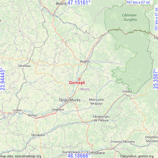
Gorneşti GPS coordinates[2]
46° 40' 16.644" North, 24° 38' 51.252" East
| Map corner | latitude | longitude |
|---|---|---|
| Upper-left | 47.15161°, | 23.94445° |
| Center: | 46.67129°, | 24.64757° |
| Lower-right: | 46.18666°, | 25.3507° |
| Map W x H: | 107.3×107.3 km | = 66.7×66.7mi |
| max Lat: | 48.23793° ⇑29% North |
| Gorneşti: | 46.67129° |
| min Lat: | ⇓71% South 43.65638° |
| min Long | Gorneşti | max Long |
| 20.31667° | 24.64757° | 29.65403° |
| W 41.8%⇐ | ⇒58.2% E |
Elevation
Elevation of Gorneşti is 338 m = 1109 ft, and this is 83.1 m = 273 ft above average elevation for this country.
| Max E: |
1278 m = 4193 ft | 27.3% |
| Gorneşti | 338 m 1109 ft | |
| Avg. | 254.9 m = 836 ft | |
Min E: |
-2 m = -7 ft | 72.7% |
See also: Romania elevation on elevation.city.
Geographical zone
Gorneşti is located in North temperate zone (between Tropic of Cancer and the Arctic Circle). Distance of this North polar circle is 2211.8 km =1374.3 mi to North.| Distance of | km | miles | from Gorneşti |
|---|---|---|---|
| North Pole | 4817.7 | 2993.6 | to North |
| Arctic Circle | 2211.8 | 1374.3 | to North |
| Tropic Cancer | 2583.4 | 1605.2 | to South |
| Equator | 5189.4 | 3224.5 | to South |


Nearby cities:
15 places around Gorneşti: (largest is in red/bold)
• Apalina
9.7 km =6 mi,  21°
21°
• Breaza
10.7 km =6.6 mi,  354°
354°
• Ceuașu de Câmpie
10.8 km =6.7 mi,  247°
247°
• Chinari
8.6 km =5.3 mi,  211°
211°
• Curteni
10.2 km =6.3 mi, 212°
• Călușeri
9.9 km =6.2 mi,  136°
136°
• Ernei
7.4 km =4.6 mi,  183°
183°
• Filpișu Mare
10.2 km =6.3 mi,  334°
334°
• Glodeni
4.3 km =2.7 mi,  236°
236°
• Iernuțeni
11.7 km =7.3 mi,  27°
27°
• Petelea
7.8 km =4.8 mi,  35°
35°
• Petrilaca de Mureș
8.3 km =5.2 mi,  75°
75°
• Păingeni
6.6 km =4.1 mi,  278°
278°
• Sângeorgiu de Mureş
12 km =7.5 mi,  199°
199°
• Voivodeni
3.4 km =2.1 mi,  341°
341°
Sources, notices
• [Note1] Compared only with cities in Romania existing in our database
• [Src1] Map data: © OpenStreetMap contributors (CC-BY-SA)
• [Src2] Other city data from geonames.org with taken over terms of usage.
• [Src3] Geographical zone / Annual Mean Temperature by Robert A. Rohde @ Wikipedia
