Voivodeni geodata
Voivodeni (Mureş) is a seat of a second-order administrative division; located in Romania in Europe/Bucharest (GMT+3) time zone. With population of 1,930 people, there are 2672 cities with bigger population in this country. Compared to other cities in Romania, 71.7% of cities are located further ↓South; 58.4% of cities are located further →East and 72.8% of cities have lower elevation than Voivodeni. Note1


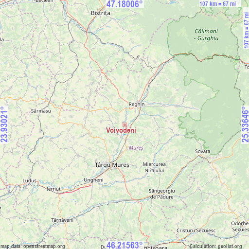
Voivodeni GPS coordinates[2]
46° 42' 0" North, 24° 37' 59.988" East
| Map corner | latitude | longitude |
|---|---|---|
| Upper-left | 47.18006°, | 23.93021° |
| Center: | 46.7°, | 24.63333° |
| Lower-right: | 46.21563°, | 25.33646° |
| Map W x H: | 107.2×107.2 km | = 66.6×66.6mi |
| max Lat: | 48.23793° ⇑28.3% North |
| Voivodeni: | 46.7° |
| min Lat: | ⇓71.7% South 43.65638° |
| min Long | Voivodeni | max Long |
| 20.31667° | 24.63333° | 29.65403° |
| W 41.6%⇐ | ⇒58.4% E |
Elevation
Elevation of Voivodeni is 339 m = 1112 ft, and this is 84.1 m = 276 ft above average elevation for this country.
| Max E: |
1278 m = 4193 ft | 27.2% |
| Voivodeni | 339 m 1112 ft | |
| Avg. | 254.9 m = 836 ft | |
Min E: |
-2 m = -7 ft | 72.8% |
See also: Romania elevation on elevation.city.
Geographical zone
Voivodeni is located in North temperate zone (between Tropic of Cancer and the Arctic Circle). Distance of this North polar circle is 2208.6 km =1372.4 mi to North.| Distance of | km | miles | from Voivodeni |
|---|---|---|---|
| North Pole | 4814.5 | 2991.6 | to North |
| Arctic Circle | 2208.6 | 1372.4 | to North |
| Tropic Cancer | 2586.6 | 1607.2 | to South |
| Equator | 5192.6 | 3226.5 | to South |


Nearby cities:
15 places around Voivodeni: (largest is in red/bold)
• Apalina
7.4 km =4.6 mi,  38°
38°
• Breaza
7.4 km =4.6 mi,  0°
0°
• Băla
10.3 km =6.4 mi,  280°
280°
• Chinari
11 km =6.8 mi,  197°
197°
• Ernei
10.6 km =6.6 mi,  176°
176°
• Filpișu Mare
6.9 km =4.3 mi,  330°
330°
• Glodeni
6.1 km =3.8 mi, 204°
• Gorneşti
3.4 km =2.1 mi,  161°
161°
• Iernuțeni
9.7 km =6 mi, 42°
• Petelea
6.4 km =4 mi,  60°
60°
• Petrilaca de Mureș
9.2 km =5.7 mi,  96°
96°
• Păingeni
5.9 km =3.7 mi,  247°
247°
• Reghin
9.8 km =6.1 mi,  32°
32°
• Reghin-Sat
11.2 km =7 mi, 34°
• Tonciu
10.9 km =6.8 mi, 325°
Sources, notices
• [Note1] Compared only with cities in Romania existing in our database
• [Src1] Map data: © OpenStreetMap contributors (CC-BY-SA)
• [Src2] Other city data from geonames.org with taken over terms of usage.
• [Src3] Geographical zone / Annual Mean Temperature by Robert A. Rohde @ Wikipedia
