Glodeni geodata
Glodeni (Mureş) is a seat of a second-order administrative division; located in Romania in Europe/Bucharest (GMT+3) time zone. With population of 3,719 people, there are 1312 cities with bigger population in this country. Compared to other cities in Romania, 70.5% of cities are located further ↓South; 58.9% of cities are located further →East and 75.7% of cities have lower elevation than Glodeni. Note1


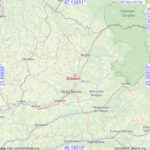
Glodeni GPS coordinates[2]
46° 39' 0" North, 24° 36' 0" East
| Map corner | latitude | longitude |
|---|---|---|
| Upper-left | 47.13051°, | 23.89688° |
| Center: | 46.65°, | 24.6° |
| Lower-right: | 46.16518°, | 25.30313° |
| Map W x H: | 107.3×107.3 km | = 66.7×66.7mi |
| max Lat: | 48.23793° ⇑29.5% North |
| Glodeni: | 46.65° |
| min Lat: | ⇓70.5% South 43.65638° |
| min Long | Glodeni | max Long |
| 20.31667° | 24.6° | 29.65403° |
| W 41.1%⇐ | ⇒58.9% E |
Elevation
Elevation of Glodeni is 359 m = 1178 ft, and this is 104.1 m = 342 ft above average elevation for this country.
| Max E: |
1278 m = 4193 ft | 24.3% |
| Glodeni | 359 m 1178 ft | |
| Avg. | 254.9 m = 836 ft | |
Min E: |
-2 m = -7 ft | 75.7% |
See also: Romania elevation on elevation.city.
Geographical zone
Glodeni is located in North temperate zone (between Tropic of Cancer and the Arctic Circle). Distance of this North polar circle is 2214.2 km =1375.8 mi to North.| Distance of | km | miles | from Glodeni |
|---|---|---|---|
| North Pole | 4820.1 | 2995.1 | to North |
| Arctic Circle | 2214.2 | 1375.8 | to North |
| Tropic Cancer | 2581.1 | 1603.8 | to South |
| Equator | 5187 | 3223.1 | to South |


Nearby cities:
15 places around Glodeni: (largest is in red/bold)
• Băla
10.6 km =6.6 mi,  314°
314°
• Ceuașu de Câmpie
6.6 km =4.1 mi,  253°
253°
• Chinari
5 km =3.1 mi,  188°
188°
• Curteni
6.5 km =4 mi,  197°
197°
• Călușeri
11.5 km =7.1 mi,  114°
114°
• Ernei
5.9 km =3.7 mi,  147°
147°
• Filpișu Mare
11.6 km =7.2 mi,  356°
356°
• Gorneşti
4.3 km =2.7 mi,  56°
56°
• Livezeni
11.4 km =7.1 mi,  167°
167°
• Păingeni
4.4 km =2.7 mi,  318°
318°
• Remetea
10.7 km =6.6 mi,  218°
218°
• Sângeorgiu de Mureş
8.9 km =5.5 mi,  182°
182°
• Sântana de Mureş
10 km =6.2 mi, 202°
• Săbed
11.8 km =7.3 mi,  277°
277°
• Voivodeni
6.1 km =3.8 mi,  24°
24°
Sources, notices
• [Note1] Compared only with cities in Romania existing in our database
• [Src1] Map data: © OpenStreetMap contributors (CC-BY-SA)
• [Src2] Other city data from geonames.org with taken over terms of usage.
• [Src3] Geographical zone / Annual Mean Temperature by Robert A. Rohde @ Wikipedia
