Gepiu geodata
Gepiu (Bihor) is a seat of a second-order administrative division; located in Romania in Europe/Bucharest (GMT+3) time zone. With population of 1,017 people, there are 4236 cities with bigger population in this country. Compared to other cities in Romania, 77.2% of cities are located further ↓South; 95.9% of cities are located further →East and 75.6% of cities have higher elevation than Gepiu. Note1


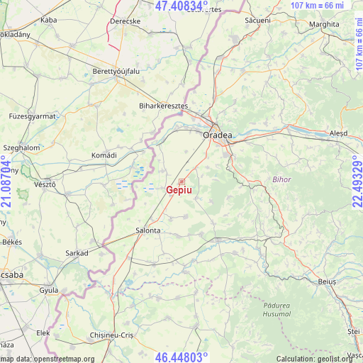
Gepiu GPS coordinates[2]
46° 55' 49.224" North, 21° 47' 24.576" East
| Map corner | latitude | longitude |
|---|---|---|
| Upper-left | 47.40834°, | 21.08704° |
| Center: | 46.93034°, | 21.79016° |
| Lower-right: | 46.44803°, | 22.49329° |
| Map W x H: | 106.8×106.8 km | = 66.4×66.4mi |
| max Lat: | 48.23793° ⇑22.8% North |
| Gepiu: | 46.93034° |
| min Lat: | ⇓77.2% South 43.65638° |
| min Long | Gepiu | max Long |
| 20.31667° | 21.79016° | 29.65403° |
| W 4.1%⇐ | ⇒95.9% E |
Elevation
Elevation of Gepiu is 108 m = 354 ft, and this is 146.9 m = 482 ft below average elevation for this country.
| Max E: |
1278 m = 4193 ft | 75.6% |
| Avg. | 254.9 m = 836 ft | |
| Gepiu | 108 m = 354 ft | |
Min E: |
-2 m = -7 ft | 24.4% |
See also: Romania elevation on elevation.city.
Geographical zone
Gepiu is located in North temperate zone (between Tropic of Cancer and the Arctic Circle). Distance of this North polar circle is 2183 km =1356.5 mi to North.| Distance of | km | miles | from Gepiu |
|---|---|---|---|
| North Pole | 4788.9 | 2975.7 | to North |
| Arctic Circle | 2183 | 1356.5 | to North |
| Tropic Cancer | 2612.2 | 1623.1 | to South |
| Equator | 5218.2 | 3242.4 | to South |


Nearby cities:
15 places around Gepiu: (largest is in red/bold)
• Bicaci
3.2 km =2 mi,  183°
183°
• Cefa
4.6 km =2.9 mi,  250°
250°
• Cihei
14.5 km =9 mi,  58°
58°
• Cordău
14.8 km =9.2 mi,  81°
81°
• Homorog
11.6 km =7.2 mi,  196°
196°
• Ianoșda
10.4 km =6.5 mi,  172°
172°
• Inand
5 km =3.1 mi,  217°
217°
• Leș
5.4 km =3.4 mi,  44°
44°
• Livada de Bihor
9 km =5.6 mi,  8°
8°
• Mădăraş
13.5 km =8.4 mi, 216°
• Nojorid
9.2 km =5.7 mi,  50°
50°
• Roit
8.4 km =5.2 mi,  313°
313°
• Sititelec
10.4 km =6.5 mi,  125°
125°
• Sânnicolau Român
6.7 km =4.2 mi,  300°
300°
• Toboliu
13.5 km =8.4 mi,  336°
336°
Sources, notices
• [Note1] Compared only with cities in Romania existing in our database
• [Src1] Map data: © OpenStreetMap contributors (CC-BY-SA)
• [Src2] Other city data from geonames.org with taken over terms of usage.
• [Src3] Geographical zone / Annual Mean Temperature by Robert A. Rohde @ Wikipedia
