Câmpeni geodata
Câmpeni (Dolj) is a populated place; located in Romania in Europe/Bucharest (GMT+3) time zone. With population of 992 people, there are 4319 cities with bigger population in this country. Compared to other cities in Romania, 89.1% of cities are located further ↑North; 69.2% of cities are located further →East and 58.1% of cities have higher elevation than Câmpeni. Note1


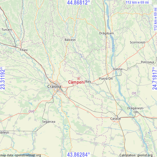
Câmpeni GPS coordinates[2]
44° 22' 3.504" North, 24° 0' 54.144" East
| Map corner | latitude | longitude |
|---|---|---|
| Upper-left | 44.86812°, | 23.31192° |
| Center: | 44.36764°, | 24.01504° |
| Lower-right: | 43.86284°, | 24.71817° |
| Map W x H: | 111.8×111.8 km | = 69.5×69.5mi |
| max Lat: | 48.23793° ⇑89.1% North |
| Câmpeni: | 44.36764° |
| min Lat: | ⇓10.9% South 43.65638° |
| min Long | Câmpeni | max Long |
| 20.31667° | 24.01504° | 29.65403° |
| W 30.8%⇐ | ⇒69.2% E |
Elevation
Elevation of Câmpeni is 173 m = 568 ft, and this is 81.9 m = 269 ft below average elevation for this country.
| Max E: |
1278 m = 4193 ft | 58.1% |
| Avg. | 254.9 m = 836 ft | |
| Câmpeni | 173 m = 568 ft | |
Min E: |
-2 m = -7 ft | 41.9% |
See also: Romania elevation on elevation.city.
Geographical zone
Câmpeni is located in North temperate zone (between Tropic of Cancer and the Arctic Circle). Distance of this Northern Tropic circle is 2327.3 km =1446.1 mi to South.| Distance of | km | miles | from Câmpeni |
|---|---|---|---|
| North Pole | 5073.8 | 3152.7 | to North |
| Arctic Circle | 2468 | 1533.5 | to North |
| Tropic Cancer | 2327.3 | 1446.1 | to South |
| Equator | 4933.2 | 3065.3 | to South |


Nearby cities:
15 places around Câmpeni: (largest is in red/bold)
• Baldovineşti
3.3 km =2.1 mi,  57°
57°
• Balş
7 km =4.3 mi,  106°
106°
• Băleasa
3.5 km =2.2 mi,  351°
351°
• Corbeni
7.7 km =4.8 mi,  80°
80°
• Călui
10.2 km =6.3 mi,  22°
22°
• Ghercești
9.5 km =5.9 mi,  261°
261°
• Golfin
8.5 km =5.3 mi,  176°
176°
• Gropșani
8.9 km =5.5 mi,  336°
336°
• Gura Căluiu
10.3 km =6.4 mi,  9°
9°
• Găvănești
5.5 km =3.4 mi,  1°
1°
• Oboga
8.7 km =5.4 mi,  51°
51°
• Pieleştí
6.4 km =4 mi,  233°
233°
• Racovița
10.2 km =6.3 mi,  124°
124°
• Robăneștii de Sus
5.1 km =3.2 mi,  187°
187°
• Teiș
9.6 km =6 mi,  101°
101°
Sources, notices
• [Note1] Compared only with cities in Romania existing in our database
• [Src1] Map data: © OpenStreetMap contributors (CC-BY-SA)
• [Src2] Other city data from geonames.org with taken over terms of usage.
• [Src3] Geographical zone / Annual Mean Temperature by Robert A. Rohde @ Wikipedia
