Balş geodata
Balş (Olt) is a seat of a second-order administrative division; located in Romania in Europe/Bucharest (GMT+3) time zone. With population of 20,626 people, there are 100 cities with bigger population in this country. Compared to other cities in Romania, 89.7% of cities are located further ↑North; 67.8% of cities are located further →East and 68.4% of cities have higher elevation than Balş. Note1


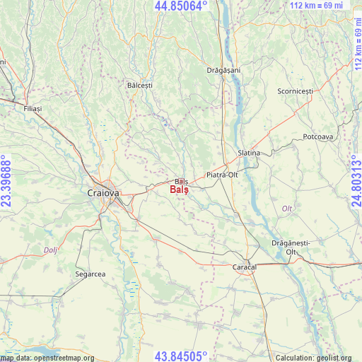
Balş GPS coordinates[2]
44° 21' 0" North, 24° 6' 0" East
| Map corner | latitude | longitude |
|---|---|---|
| Upper-left | 44.85064°, | 23.39688° |
| Center: | 44.35°, | 24.1° |
| Lower-right: | 43.84505°, | 24.80313° |
| Map W x H: | 111.8×111.8 km | = 69.5×69.5mi |
| max Lat: | 48.23793° ⇑89.7% North |
| Balş: | 44.35° |
| min Lat: | ⇓10.3% South 43.65638° |
| min Long | Balş | max Long |
| 20.31667° | 24.1° | 29.65403° |
| W 32.2%⇐ | ⇒67.8% E |
Elevation
Elevation of Balş is 133 m = 436 ft, and this is 121.9 m = 400 ft below average elevation for this country.
| Max E: |
1278 m = 4193 ft | 68.4% |
| Avg. | 254.9 m = 836 ft | |
| Balş | 133 m = 436 ft | |
Min E: |
-2 m = -7 ft | 31.6% |
See also: Romania elevation on elevation.city.
Geographical zone
Balş is located in North temperate zone (between Tropic of Cancer and the Arctic Circle). Distance of this Northern Tropic circle is 2325.3 km =1444.9 mi to South.| Distance of | km | miles | from Balş |
|---|---|---|---|
| North Pole | 5075.8 | 3154 | to North |
| Arctic Circle | 2469.9 | 1534.7 | to North |
| Tropic Cancer | 2325.3 | 1444.9 | to South |
| Equator | 4931.3 | 3064.2 | to South |


Nearby cities:
15 places around Balş: (largest is in red/bold)
• Baldovineşti
5.4 km =3.4 mi,  312°
312°
• Bobiceşti
5.4 km =3.4 mi,  47°
47°
• Braneț
6.8 km =4.2 mi,  113°
113°
• Bârza
4.1 km =2.5 mi,  126°
126°
• Corbeni
3.4 km =2.1 mi,  13°
13°
• Câmpeni
7 km =4.3 mi,  286°
286°
• Golfin
9.1 km =5.7 mi,  223°
223°
• Leotești
4.6 km =2.9 mi,  65°
65°
• Mirila
4.2 km =2.6 mi,  78°
78°
• Mărgăritești
6.9 km =4.3 mi,  146°
146°
• Oboga
7.4 km =4.6 mi,  0°
0°
• Racovița
4.2 km =2.6 mi,  157°
157°
• Robăneștii de Sus
8 km =5 mi,  247°
247°
• Teiș
2.7 km =1.7 mi,  90°
90°
• Voineasa
7.9 km =4.9 mi, 160°
Sources, notices
• [Note1] Compared only with cities in Romania existing in our database
• [Src1] Map data: © OpenStreetMap contributors (CC-BY-SA)
• [Src2] Other city data from geonames.org with taken over terms of usage.
• [Src3] Geographical zone / Annual Mean Temperature by Robert A. Rohde @ Wikipedia
