Finișel geodata
Finișel (Cluj) is a populated place; located in Romania in Europe/Bucharest (GMT+3) time zone. With population of 849 people, there are 4845 cities with bigger population in this country. Compared to other cities in Romania, 71.1% of cities are located further ↓South; 78.1% of cities are located further →East and 90.7% of cities have lower elevation than Finișel. Note1


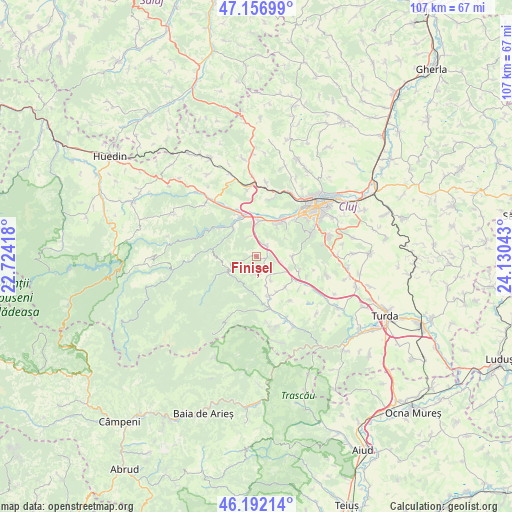
Finișel GPS coordinates[2]
46° 40' 36.192" North, 23° 25' 38.28" East
| Map corner | latitude | longitude |
|---|---|---|
| Upper-left | 47.15699°, | 22.72418° |
| Center: | 46.67672°, | 23.4273° |
| Lower-right: | 46.19214°, | 24.13043° |
| Map W x H: | 107.3×107.3 km | = 66.7×66.7mi |
| max Lat: | 48.23793° ⇑28.9% North |
| Finișel: | 46.67672° |
| min Lat: | ⇓71.1% South 43.65638° |
| min Long | Finișel | max Long |
| 20.31667° | 23.4273° | 29.65403° |
| W 21.9%⇐ | ⇒78.1% E |
Elevation
Elevation of Finișel is 525 m = 1722 ft, and this is 270.1 m = 886 ft above average elevation for this country.
| Max E: |
1278 m = 4193 ft | 9.3% |
| Finișel | 525 m 1722 ft | |
| Avg. | 254.9 m = 836 ft | |
Min E: |
-2 m = -7 ft | 90.7% |
See also: Romania elevation on elevation.city.
Geographical zone
Finișel is located in North temperate zone (between Tropic of Cancer and the Arctic Circle). Distance of this North polar circle is 2211.2 km =1374 mi to North.| Distance of | km | miles | from Finișel |
|---|---|---|---|
| North Pole | 4817.1 | 2993.2 | to North |
| Arctic Circle | 2211.2 | 1374 | to North |
| Tropic Cancer | 2584 | 1605.6 | to South |
| Equator | 5190 | 3224.9 | to South |


Nearby cities:
15 places around Finișel: (largest is in red/bold)
• Agriș
11.7 km =7.3 mi,  142°
142°
• Băişoara
10.8 km =6.7 mi,  163°
163°
• Ciurila
9.8 km =6.1 mi,  107°
107°
• Floreşti
9.2 km =5.7 mi,  33°
33°
• Gilău
8 km =5 mi,  321°
321°
• Hășdate
3.7 km =2.3 mi,  178°
178°
• Luna de Sus
7.4 km =4.6 mi,  4°
4°
• Micești
15 km =9.3 mi,  104°
104°
• Muntele Rece
11.4 km =7.1 mi,  252°
252°
• Someșu Cald
9.7 km =6 mi,  310°
310°
• Suceagu
12.3 km =7.6 mi,  13°
13°
• Săvădisla
1.9 km =1.2 mi,  67°
67°
• Valea Ierii
6.6 km =4.1 mi,  243°
243°
• Viștea
14.1 km =8.8 mi,  352°
352°
• Vlaha
3.1 km =1.9 mi,  44°
44°
Sources, notices
• [Note1] Compared only with cities in Romania existing in our database
• [Src1] Map data: © OpenStreetMap contributors (CC-BY-SA)
• [Src2] Other city data from geonames.org with taken over terms of usage.
• [Src3] Geographical zone / Annual Mean Temperature by Robert A. Rohde @ Wikipedia
