Băişoara geodata
Băişoara (Cluj) is a seat of a second-order administrative division; located in Romania in Europe/Bucharest (GMT+3) time zone. With population of 2,319 people, there are 2303 cities with bigger population in this country. Compared to other cities in Romania, 69% of cities are located further ↓South; 77.6% of cities are located further →East and 91.8% of cities have lower elevation than Băişoara. Note1


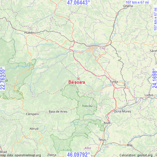
Băişoara GPS coordinates[2]
46° 34' 59.988" North, 23° 28' 0.012" East
| Map corner | latitude | longitude |
|---|---|---|
| Upper-left | 47.06443°, | 22.76355° |
| Center: | 46.58333°, | 23.46667° |
| Lower-right: | 46.09792°, | 24.1698° |
| Map W x H: | 107.5×107.5 km | = 66.8×66.8mi |
| max Lat: | 48.23793° ⇑31% North |
| Băişoara: | 46.58333° |
| min Lat: | ⇓69% South 43.65638° |
| min Long | Băişoara | max Long |
| 20.31667° | 23.46667° | 29.65403° |
| W 22.4%⇐ | ⇒77.6% E |
Elevation
Elevation of Băişoara is 545 m = 1788 ft, and this is 290.1 m = 952 ft above average elevation for this country.
| Max E: |
1278 m = 4193 ft | 8.2% |
| Băişoara | 545 m 1788 ft | |
| Avg. | 254.9 m = 836 ft | |
Min E: |
-2 m = -7 ft | 91.8% |
See also: Romania elevation on elevation.city.
Geographical zone
Băişoara is located in North temperate zone (between Tropic of Cancer and the Arctic Circle). Distance of this North polar circle is 2221.6 km =1380.4 mi to North.| Distance of | km | miles | from Băişoara |
|---|---|---|---|
| North Pole | 4827.5 | 2999.7 | to North |
| Arctic Circle | 2221.6 | 1380.4 | to North |
| Tropic Cancer | 2573.7 | 1599.2 | to South |
| Equator | 5179.6 | 3218.5 | to South |


Nearby cities:
15 places around Băişoara: (largest is in red/bold)
• Agriș
4.3 km =2.7 mi,  74°
74°
• Cacova Ierii
4.5 km =2.8 mi,  172°
172°
• Ciurila
9.8 km =6.1 mi,  40°
40°
• Finișel
10.8 km =6.7 mi,  343°
343°
• Hășdate
7.3 km =4.5 mi, 336°
• Iara
5.3 km =3.3 mi,  134°
134°
• Micești
13.3 km =8.3 mi,  60°
60°
• Muntele Rece
15.5 km =9.6 mi,  296°
296°
• Ocoliş
11.1 km =6.9 mi,  180°
180°
• Petreştii de Jos
14 km =8.7 mi,  90°
90°
• Poşaga de Sus
14.5 km =9 mi,  206°
206°
• Rimetea
16.7 km =10.4 mi,  152°
152°
• Săvădisla
11.2 km =7 mi,  353°
353°
• Valea Ierii
11.6 km =7.2 mi,  309°
309°
• Vlaha
12.6 km =7.8 mi,  356°
356°
Sources, notices
• [Note1] Compared only with cities in Romania existing in our database
• [Src1] Map data: © OpenStreetMap contributors (CC-BY-SA)
• [Src2] Other city data from geonames.org with taken over terms of usage.
• [Src3] Geographical zone / Annual Mean Temperature by Robert A. Rohde @ Wikipedia
