Agriș geodata
Agriș (Cluj) is a populated place; located in Romania in Europe/Bucharest (GMT+3) time zone. With population of 608 people, there are 6143 cities with bigger population in this country. Compared to other cities in Romania, 69.3% of cities are located further ↓South; 76.7% of cities are located further →East and 96.1% of cities have lower elevation than Agriș. Note1


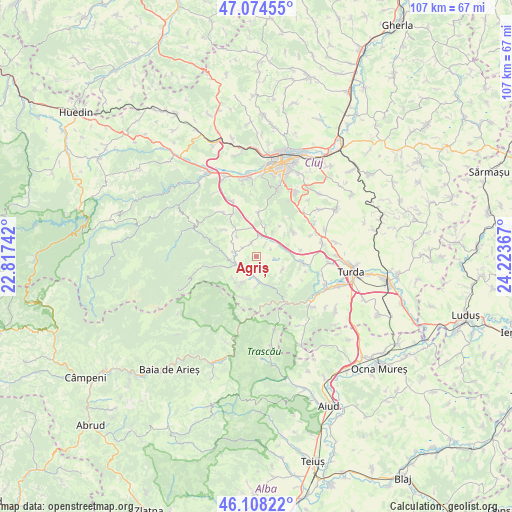
Agriș GPS coordinates[2]
46° 35' 36.744" North, 23° 31' 13.944" East
| Map corner | latitude | longitude |
|---|---|---|
| Upper-left | 47.07455°, | 22.81742° |
| Center: | 46.59354°, | 23.52054° |
| Lower-right: | 46.10822°, | 24.22367° |
| Map W x H: | 107.4×107.4 km | = 66.7×66.7mi |
| max Lat: | 48.23793° ⇑30.7% North |
| Agriș: | 46.59354° |
| min Lat: | ⇓69.3% South 43.65638° |
| min Long | Agriș | max Long |
| 20.31667° | 23.52054° | 29.65403° |
| W 23.3%⇐ | ⇒76.7% E |
Elevation
Elevation of Agriș is 673 m = 2208 ft, and this is 418.1 m = 1372 ft above average elevation for this country.
| Max E: |
1278 m = 4193 ft | 3.9% |
| Agriș | 673 m 2208 ft | |
| Avg. | 254.9 m = 836 ft | |
Min E: |
-2 m = -7 ft | 96.1% |
See also: Romania elevation on elevation.city.
Geographical zone
Agriș is located in North temperate zone (between Tropic of Cancer and the Arctic Circle). Distance of this North polar circle is 2220.5 km =1379.8 mi to North.| Distance of | km | miles | from Agriș |
|---|---|---|---|
| North Pole | 4826.3 | 2998.9 | to North |
| Arctic Circle | 2220.5 | 1379.8 | to North |
| Tropic Cancer | 2574.8 | 1599.9 | to South |
| Equator | 5180.7 | 3219.1 | to South |


Nearby cities:
15 places around Agriș: (largest is in red/bold)
• Băişoara
4.3 km =2.7 mi,  254°
254°
• Cacova Ierii
6.6 km =4.1 mi,  212°
212°
• Ciurila
6.7 km =4.2 mi,  19°
19°
• Finișel
11.7 km =7.3 mi,  322°
322°
• Hășdate
9 km =5.6 mi,  308°
308°
• Iara
4.9 km =3 mi,  183°
183°
• Micești
9.2 km =5.7 mi,  53°
53°
• Moldoveneşti
14.4 km =8.9 mi,  136°
136°
• Ocoliş
12.9 km =8 mi,  198°
198°
• Petreştii de Jos
10 km =6.2 mi,  96°
96°
• Săvădisla
11.3 km =7 mi,  331°
331°
• Tureni
14.4 km =8.9 mi,  74°
74°
• Valea Ierii
14.5 km =9 mi,  295°
295°
• Vlaha
12.5 km =7.8 mi,  336°
336°
• Vâlcele
14.5 km =9 mi,  44°
44°
Sources, notices
• [Note1] Compared only with cities in Romania existing in our database
• [Src1] Map data: © OpenStreetMap contributors (CC-BY-SA)
• [Src2] Other city data from geonames.org with taken over terms of usage.
• [Src3] Geographical zone / Annual Mean Temperature by Robert A. Rohde @ Wikipedia
