Hășdate geodata
Hășdate (Cluj) is a populated place; located in Romania in Europe/Bucharest (GMT+3) time zone. With population of 653 people, there are 5874 cities with bigger population in this country. Compared to other cities in Romania, 70.4% of cities are located further ↓South; 78.1% of cities are located further →East and 94.7% of cities have lower elevation than Hășdate. Note1


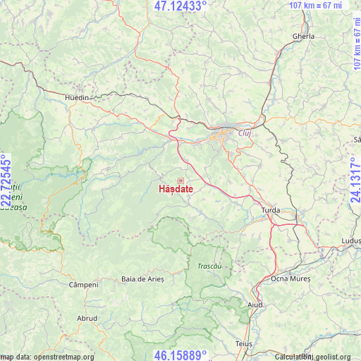
Hășdate GPS coordinates[2]
46° 38' 37.536" North, 23° 25' 42.852" East
| Map corner | latitude | longitude |
|---|---|---|
| Upper-left | 47.12433°, | 22.72545° |
| Center: | 46.64376°, | 23.42857° |
| Lower-right: | 46.15889°, | 24.1317° |
| Map W x H: | 107.3×107.3 km | = 66.7×66.7mi |
| max Lat: | 48.23793° ⇑29.6% North |
| Hășdate: | 46.64376° |
| min Lat: | ⇓70.4% South 43.65638° |
| min Long | Hășdate | max Long |
| 20.31667° | 23.42857° | 29.65403° |
| W 21.9%⇐ | ⇒78.1% E |
Elevation
Elevation of Hășdate is 617 m = 2024 ft, and this is 362.1 m = 1188 ft above average elevation for this country.
| Max E: |
1278 m = 4193 ft | 5.3% |
| Hășdate | 617 m 2024 ft | |
| Avg. | 254.9 m = 836 ft | |
Min E: |
-2 m = -7 ft | 94.7% |
See also: Romania elevation on elevation.city.
Geographical zone
Hășdate is located in North temperate zone (between Tropic of Cancer and the Arctic Circle). Distance of this North polar circle is 2214.9 km =1376.3 mi to North.| Distance of | km | miles | from Hășdate |
|---|---|---|---|
| North Pole | 4820.8 | 2995.5 | to North |
| Arctic Circle | 2214.9 | 1376.3 | to North |
| Tropic Cancer | 2580.4 | 1603.4 | to South |
| Equator | 5186.3 | 3222.6 | to South |


Nearby cities:
15 places around Hășdate: (largest is in red/bold)
• Agriș
9 km =5.6 mi,  128°
128°
• Băişoara
7.3 km =4.5 mi,  156°
156°
• Cacova Ierii
11.7 km =7.3 mi, 162°
• Ciurila
9.3 km =5.8 mi,  85°
85°
• Finișel
3.7 km =2.3 mi,  358°
358°
• Floreşti
12.4 km =7.7 mi,  23°
23°
• Gilău
11.1 km =6.9 mi,  332°
332°
• Iara
12.4 km =7.7 mi,  147°
147°
• Luna de Sus
11.1 km =6.9 mi,  2°
2°
• Micești
14.4 km =8.9 mi, 90°
• Muntele Rece
11 km =6.8 mi,  270°
270°
• Someșu Cald
12.4 km =7.7 mi,  322°
322°
• Săvădisla
4.7 km =2.9 mi, 20°
• Valea Ierii
6 km =3.7 mi,  276°
276°
• Vlaha
6.2 km =3.9 mi, 19°
Sources, notices
• [Note1] Compared only with cities in Romania existing in our database
• [Src1] Map data: © OpenStreetMap contributors (CC-BY-SA)
• [Src2] Other city data from geonames.org with taken over terms of usage.
• [Src3] Geographical zone / Annual Mean Temperature by Robert A. Rohde @ Wikipedia
