Dragodana geodata
Dragodana (Dâmboviţa) is a seat of a second-order administrative division; located in Romania in Europe/Bucharest (GMT+3) time zone. With population of 6,918 people, there are 419 cities with bigger population in this country. Compared to other cities in Romania, 79% of cities are located further ↑North; 52% of cities are located further ←West and 55.6% of cities have higher elevation than Dragodana. Note1


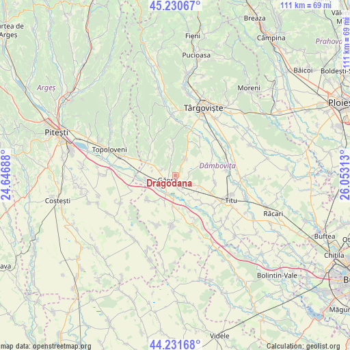
Dragodana GPS coordinates[2]
44° 43' 59.988" North, 25° 21' 0" East
| Map corner | latitude | longitude |
|---|---|---|
| Upper-left | 45.23067°, | 24.64688° |
| Center: | 44.73333°, | 25.35° |
| Lower-right: | 44.23168°, | 26.05313° |
| Map W x H: | 111.1×111.1 km | = 69×69mi |
| max Lat: | 48.23793° ⇑79% North |
| Dragodana: | 44.73333° |
| min Lat: | ⇓21% South 43.65638° |
| min Long | Dragodana | max Long |
| 20.31667° | 25.35° | 29.65403° |
| W 52%⇐ | ⇒48% E |
Elevation
Elevation of Dragodana is 184 m = 604 ft, and this is 70.9 m = 233 ft below average elevation for this country.
| Max E: |
1278 m = 4193 ft | 55.6% |
| Avg. | 254.9 m = 836 ft | |
| Dragodana | 184 m = 604 ft | |
Min E: |
-2 m = -7 ft | 44.4% |
See also: Romania elevation on elevation.city.
Geographical zone
Dragodana is located in North temperate zone (between Tropic of Cancer and the Arctic Circle). Distance of this Northern Tropic circle is 2368 km =1471.4 mi to South.| Distance of | km | miles | from Dragodana |
|---|---|---|---|
| North Pole | 5033.2 | 3127.5 | to North |
| Arctic Circle | 2427.3 | 1508.3 | to North |
| Tropic Cancer | 2368 | 1471.4 | to South |
| Equator | 4973.9 | 3090.6 | to South |


Nearby cities:
15 places around Dragodana: (largest is in red/bold)
• Boboci
8.1 km =5 mi,  26°
26°
• Burduca
4.5 km =2.8 mi,  76°
76°
• Bădulești
7 km =4.3 mi,  296°
296°
• Cojocaru
5 km =3.1 mi,  149°
149°
• Cuparu
4.2 km =2.6 mi,  106°
106°
• Gherghești
6.7 km =4.2 mi,  208°
208°
• Greci
8 km =5 mi,  183°
183°
• Gura Foii
5.6 km =3.5 mi,  289°
289°
• Găeşti
3.2 km =2 mi,  234°
234°
• Ionești
7.2 km =4.5 mi, 232°
• Merii
4.4 km =2.7 mi,  166°
166°
• Mogoşani
6.8 km =4.2 mi,  144°
144°
• Mănăstirea
4.5 km =2.8 mi,  324°
324°
• Mătăsaru
5.6 km =3.5 mi, 109°
• Picior de Munte
6.3 km =3.9 mi, 30°
Sources, notices
• [Note1] Compared only with cities in Romania existing in our database
• [Src1] Map data: © OpenStreetMap contributors (CC-BY-SA)
• [Src2] Other city data from geonames.org with taken over terms of usage.
• [Src3] Geographical zone / Annual Mean Temperature by Robert A. Rohde @ Wikipedia
