Gherghești geodata
Gherghești (Dâmboviţa) is a populated place; located in Romania in Europe/Bucharest (GMT+3) time zone. With population of 566 people, there are 6460 cities with bigger population in this country. Compared to other cities in Romania, 80.7% of cities are located further ↑North; 51.4% of cities are located further ←West and 55.2% of cities have higher elevation than Gherghești. Note1


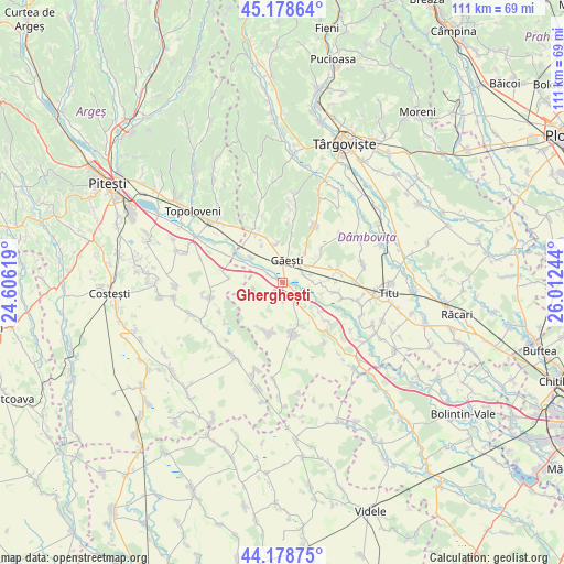
Gherghești GPS coordinates[2]
44° 40' 51.06" North, 25° 18' 33.516" East
| Map corner | latitude | longitude |
|---|---|---|
| Upper-left | 45.17864°, | 24.60619° |
| Center: | 44.68085°, | 25.30931° |
| Lower-right: | 44.17875°, | 26.01244° |
| Map W x H: | 111.2×111.2 km | = 69.1×69.1mi |
| max Lat: | 48.23793° ⇑80.7% North |
| Gherghești: | 44.68085° |
| min Lat: | ⇓19.3% South 43.65638° |
| min Long | Gherghești | max Long |
| 20.31667° | 25.30931° | 29.65403° |
| W 51.4%⇐ | ⇒48.6% E |
Elevation
Elevation of Gherghești is 186 m = 610 ft, and this is 68.9 m = 226 ft below average elevation for this country.
| Max E: |
1278 m = 4193 ft | 55.2% |
| Avg. | 254.9 m = 836 ft | |
| Gherghești | 186 m = 610 ft | |
Min E: |
-2 m = -7 ft | 44.8% |
See also: Romania elevation on elevation.city.
Geographical zone
Gherghești is located in North temperate zone (between Tropic of Cancer and the Arctic Circle). Distance of this Northern Tropic circle is 2362.1 km =1467.7 mi to South.| Distance of | km | miles | from Gherghești |
|---|---|---|---|
| North Pole | 5039 | 3131.1 | to North |
| Arctic Circle | 2433.1 | 1511.9 | to North |
| Tropic Cancer | 2362.1 | 1467.7 | to South |
| Equator | 4968 | 3087 | to South |


Nearby cities:
15 places around Gherghești: (largest is in red/bold)
• Cojocaru
6 km =3.7 mi,  74°
74°
• Cuparu
8.6 km =5.3 mi,  57°
57°
• Dragodana
6.7 km =4.2 mi,  28°
28°
• Greci
3.5 km =2.2 mi,  128°
128°
• Gura Foii
8 km =5 mi,  345°
345°
• Găeşti
4 km =2.5 mi,  8°
8°
• Ionești
2.9 km =1.8 mi,  299°
299°
• Merii
4.5 km =2.8 mi, 70°
• Mogoşani
7.2 km =4.5 mi,  87°
87°
• Morteni
6.2 km =3.9 mi,  255°
255°
• Neajlovu
4.2 km =2.6 mi,  234°
234°
• Petreşti
3.9 km =2.4 mi,  151°
151°
• Puntea de Greci
3.7 km =2.3 mi,  180°
180°
• Pătroaia Vale
8 km =5 mi,  309°
309°
• Zăvoiu
7.8 km =4.8 mi,  106°
106°
Sources, notices
• [Note1] Compared only with cities in Romania existing in our database
• [Src1] Map data: © OpenStreetMap contributors (CC-BY-SA)
• [Src2] Other city data from geonames.org with taken over terms of usage.
• [Src3] Geographical zone / Annual Mean Temperature by Robert A. Rohde @ Wikipedia
