Cojocaru geodata
Cojocaru (Dâmboviţa) is a populated place; located in Romania in Europe/Bucharest (GMT+3) time zone. With population of 834 people, there are 4907 cities with bigger population in this country. Compared to other cities in Romania, 80.2% of cities are located further ↑North; 52.3% of cities are located further ←West and 57.7% of cities have higher elevation than Cojocaru. Note1


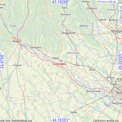
Cojocaru GPS coordinates[2]
44° 41' 42.036" North, 25° 22' 54.912" East
| Map corner | latitude | longitude |
|---|---|---|
| Upper-left | 45.19268°, | 24.6788° |
| Center: | 44.69501°, | 25.38192° |
| Lower-right: | 44.19303°, | 26.08505° |
| Map W x H: | 111.2×111.1 km | = 69.1×69mi |
| max Lat: | 48.23793° ⇑80.2% North |
| Cojocaru: | 44.69501° |
| min Lat: | ⇓19.8% South 43.65638° |
| min Long | Cojocaru | max Long |
| 20.31667° | 25.38192° | 29.65403° |
| W 52.3%⇐ | ⇒47.7% E |
Elevation
Elevation of Cojocaru is 175 m = 574 ft, and this is 79.9 m = 262 ft below average elevation for this country.
| Max E: |
1278 m = 4193 ft | 57.7% |
| Avg. | 254.9 m = 836 ft | |
| Cojocaru | 175 m = 574 ft | |
Min E: |
-2 m = -7 ft | 42.3% |
See also: Romania elevation on elevation.city.
Geographical zone
Cojocaru is located in North temperate zone (between Tropic of Cancer and the Arctic Circle). Distance of this Northern Tropic circle is 2363.7 km =1468.7 mi to South.| Distance of | km | miles | from Cojocaru |
|---|---|---|---|
| North Pole | 5037.4 | 3130.1 | to North |
| Arctic Circle | 2431.6 | 1510.9 | to North |
| Tropic Cancer | 2363.7 | 1468.7 | to South |
| Equator | 4969.6 | 3088 | to South |


Nearby cities:
15 places around Cojocaru: (largest is in red/bold)
• Burduca
5.6 km =3.5 mi,  19°
19°
• Cuparu
3.4 km =2.1 mi,  25°
25°
• Dragodana
5 km =3.1 mi,  329°
329°
• Gherghești
6 km =3.7 mi,  254°
254°
• Greci
4.8 km =3 mi,  219°
219°
• Găeşti
5.7 km =3.5 mi,  295°
295°
• Merii
1.5 km =0.9 mi,  268°
268°
• Mogoşani
1.9 km =1.2 mi,  132°
132°
• Mătăsaru
3.7 km =2.3 mi,  48°
48°
• Odaia Turcului
5.5 km =3.4 mi,  86°
86°
• Petreşti
6.3 km =3.9 mi, 217°
• Poroinica
6.3 km =3.9 mi,  124°
124°
• Puțu cu Salcie
7.6 km =4.7 mi, 128°
• Tețcoiu
4.7 km =2.9 mi,  108°
108°
• Zăvoiu
4.2 km =2.6 mi,  156°
156°
Sources, notices
• [Note1] Compared only with cities in Romania existing in our database
• [Src1] Map data: © OpenStreetMap contributors (CC-BY-SA)
• [Src2] Other city data from geonames.org with taken over terms of usage.
• [Src3] Geographical zone / Annual Mean Temperature by Robert A. Rohde @ Wikipedia
