Cuparu geodata
Cuparu (Dâmboviţa) is a populated place; located in Romania in Europe/Bucharest (GMT+3) time zone. With population of 588 people, there are 6301 cities with bigger population in this country. Compared to other cities in Romania, 79.3% of cities are located further ↑North; 52.8% of cities are located further ←West and 56.8% of cities have higher elevation than Cuparu. Note1


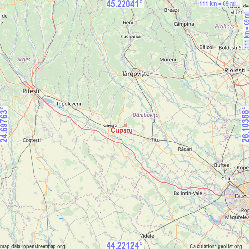
Cuparu GPS coordinates[2]
44° 43' 22.728" North, 25° 24' 2.7" East
| Map corner | latitude | longitude |
|---|---|---|
| Upper-left | 45.22041°, | 24.69763° |
| Center: | 44.72298°, | 25.40075° |
| Lower-right: | 44.22124°, | 26.10388° |
| Map W x H: | 111.1×111.1 km | = 69×69mi |
| max Lat: | 48.23793° ⇑79.3% North |
| Cuparu: | 44.72298° |
| min Lat: | ⇓20.7% South 43.65638° |
| min Long | Cuparu | max Long |
| 20.31667° | 25.40075° | 29.65403° |
| W 52.8%⇐ | ⇒47.2% E |
Elevation
Elevation of Cuparu is 179 m = 587 ft, and this is 75.9 m = 249 ft below average elevation for this country.
| Max E: |
1278 m = 4193 ft | 56.8% |
| Avg. | 254.9 m = 836 ft | |
| Cuparu | 179 m = 587 ft | |
Min E: |
-2 m = -7 ft | 43.2% |
See also: Romania elevation on elevation.city.
Geographical zone
Cuparu is located in North temperate zone (between Tropic of Cancer and the Arctic Circle). Distance of this Northern Tropic circle is 2366.8 km =1470.7 mi to South.| Distance of | km | miles | from Cuparu |
|---|---|---|---|
| North Pole | 5034.3 | 3128.2 | to North |
| Arctic Circle | 2428.4 | 1508.9 | to North |
| Tropic Cancer | 2366.8 | 1470.7 | to South |
| Equator | 4972.7 | 3089.9 | to South |


Nearby cities:
15 places around Cuparu: (largest is in red/bold)
• Burduca
2.2 km =1.4 mi,  9°
9°
• Cojocaru
3.4 km =2.1 mi,  205°
205°
• Dragodana
4.2 km =2.6 mi,  286°
286°
• Greci
8.2 km =5.1 mi, 213°
• Găeşti
6.7 km =4.2 mi,  263°
263°
• Merii
4.3 km =2.7 mi,  223°
223°
• Mogoşani
4.4 km =2.7 mi,  180°
180°
• Mătăsaru
1.4 km =0.9 mi,  119°
119°
• Odaia Turcului
4.8 km =3 mi,  125°
125°
• Picior de Munte
6.7 km =4.2 mi,  353°
353°
• Poroinica
7.6 km =4.7 mi,  151°
151°
• Produleşti
8.2 km =5.1 mi,  108°
108°
• Speriețeni
6.3 km =3.9 mi,  40°
40°
• Tețcoiu
5.5 km =3.4 mi, 146°
• Zăvoiu
7 km =4.3 mi, 178°
Sources, notices
• [Note1] Compared only with cities in Romania existing in our database
• [Src1] Map data: © OpenStreetMap contributors (CC-BY-SA)
• [Src2] Other city data from geonames.org with taken over terms of usage.
• [Src3] Geographical zone / Annual Mean Temperature by Robert A. Rohde @ Wikipedia
