Dorohoi geodata
Dorohoi (Botoşani) is a seat of a second-order administrative division; located in Romania in Europe/Bucharest (GMT+3) time zone. With population of 30,776 people, there are 68 cities with bigger population in this country. Compared to other cities in Romania, 98.6% of cities are located further ↓South; 70.8% of cities are located further ←West and 63.9% of cities have higher elevation than Dorohoi. Note1


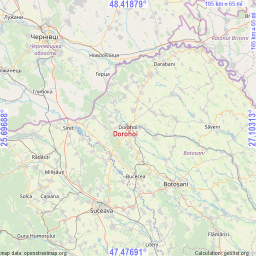
Dorohoi GPS coordinates[2]
47° 57' 0" North, 26° 24' 0" East
| Map corner | latitude | longitude |
|---|---|---|
| Upper-left | 48.41879°, | 25.69688° |
| Center: | 47.95°, | 26.4° |
| Lower-right: | 47.47691°, | 27.10313° |
| Map W x H: | 104.7×104.7 km | = 65.1×65.1mi |
| max Lat: | 48.23793° ⇑1.4% North |
| Dorohoi: | 47.95° |
| min Lat: | ⇓98.6% South 43.65638° |
| min Long | Dorohoi | max Long |
| 20.31667° | 26.4° | 29.65403° |
| W 70.8%⇐ | ⇒29.2% E |
Elevation
Elevation of Dorohoi is 151 m = 495 ft, and this is 103.9 m = 341 ft below average elevation for this country.
| Max E: |
1278 m = 4193 ft | 63.9% |
| Avg. | 254.9 m = 836 ft | |
| Dorohoi | 151 m = 495 ft | |
Min E: |
-2 m = -7 ft | 36.1% |
See also: Romania elevation on elevation.city.
Geographical zone
Dorohoi is located in North temperate zone (between Tropic of Cancer and the Arctic Circle). Distance of this North polar circle is 2069.6 km =1286 mi to North.| Distance of | km | miles | from Dorohoi |
|---|---|---|---|
| North Pole | 4675.5 | 2905.2 | to North |
| Arctic Circle | 2069.6 | 1286 | to North |
| Tropic Cancer | 2725.6 | 1693.6 | to South |
| Equator | 5331.5 | 3312.8 | to South |


Nearby cities:
15 places around Dorohoi: (largest is in red/bold)
• Broscăuţi
3.7 km =2.3 mi,  90°
90°
• Brăeşti
10 km =6.2 mi,  158°
158°
• Carasa
9 km =5.6 mi,  96°
96°
• Corlăteni
11.3 km =7 mi, 99°
• Dimăcheni
11.7 km =7.3 mi,  111°
111°
• Dumbrăvița
7.9 km =4.9 mi,  14°
14°
• George Enescu
11.1 km =6.9 mi,  33°
33°
• Hilișeu-Cloșca
8.7 km =5.4 mi,  326°
326°
• Iezer
6.2 km =3.9 mi,  306°
306°
• Lozna
9.1 km =5.7 mi,  271°
271°
• Pădureni
6.8 km =4.2 mi,  293°
293°
• Saucenița
6.3 km =3.9 mi,  181°
181°
• Străteni
7.8 km =4.8 mi,  259°
259°
• Văculeşti
7.5 km =4.7 mi,  170°
170°
• Şendriceni
5.4 km =3.4 mi, 272°
Sources, notices
• [Note1] Compared only with cities in Romania existing in our database
• [Src1] Map data: © OpenStreetMap contributors (CC-BY-SA)
• [Src2] Other city data from geonames.org with taken over terms of usage.
• [Src3] Geographical zone / Annual Mean Temperature by Robert A. Rohde @ Wikipedia
