Craiova geodata
Craiova (Dolj) is a seat of a first-order administrative division; located in Romania in Europe/Bucharest (GMT+3) time zone. With population of 304,142 people, there are 7 cities with bigger population in this country. Compared to other cities in Romania, 90.4% of cities are located further ↑North; 72.6% of cities are located further →East and 76.7% of cities have higher elevation than Craiova. Note1


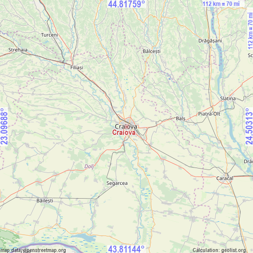
Craiova GPS coordinates[2]
44° 19' 0.012" North, 23° 48' 0" East
| Map corner | latitude | longitude |
|---|---|---|
| Upper-left | 44.81759°, | 23.09688° |
| Center: | 44.31667°, | 23.8° |
| Lower-right: | 43.81144°, | 24.50313° |
| Map W x H: | 111.9×111.9 km | = 69.5×69.5mi |
| max Lat: | 48.23793° ⇑90.4% North |
| Craiova: | 44.31667° |
| min Lat: | ⇓9.6% South 43.65638° |
| min Long | Craiova | max Long |
| 20.31667° | 23.8° | 29.65403° |
| W 27.4%⇐ | ⇒72.6% E |
Elevation
Elevation of Craiova is 105 m = 344 ft, and this is 149.9 m = 492 ft below average elevation for this country.
| Max E: |
1278 m = 4193 ft | 76.7% |
| Avg. | 254.9 m = 836 ft | |
| Craiova | 105 m = 344 ft | |
Min E: |
-2 m = -7 ft | 23.3% |
See also: Craiova elevation on elevation.city.
Geographical zone
Craiova is located in North temperate zone (between Tropic of Cancer and the Arctic Circle). Distance of this Northern Tropic circle is 2321.6 km =1442.6 mi to South.| Distance of | km | miles | from Craiova |
|---|---|---|---|
| North Pole | 5079.5 | 3156.3 | to North |
| Arctic Circle | 2473.6 | 1537 | to North |
| Tropic Cancer | 2321.6 | 1442.6 | to South |
| Equator | 4927.6 | 3061.9 | to South |


Nearby cities:
15 places around Craiova: (largest is in red/bold)
• Albești
6.9 km =4.3 mi,  337°
337°
• Braniște
5.2 km =3.2 mi,  188°
188°
• Bucovăţ
4.4 km =2.7 mi,  245°
245°
• Cernele
5 km =3.1 mi,  292°
292°
• Cernelele de Sus
5.4 km =3.4 mi,  296°
296°
• Făcăi
5.1 km =3.2 mi,  161°
161°
• Izvorul Rece
5.8 km =3.6 mi,  319°
319°
• Mofleni
3.7 km =2.3 mi,  244°
244°
• Palilula
8.2 km =5.1 mi,  229°
229°
• Podari
7.5 km =4.7 mi, 190°
• Popoveni
3.5 km =2.2 mi,  204°
204°
• Preajba
7 km =4.3 mi,  145°
145°
• Rovine
8.1 km =5 mi,  308°
308°
• Şimnicu de Sus
7.4 km =4.6 mi,  0°
0°
• Șimnicu de Jos
5.1 km =3.2 mi,  19°
19°
Sources, notices
• [Note1] Compared only with cities in Romania existing in our database
• [Src1] Map data: © OpenStreetMap contributors (CC-BY-SA)
• [Src2] Other city data from geonames.org with taken over terms of usage.
• [Src3] Geographical zone / Annual Mean Temperature by Robert A. Rohde @ Wikipedia
