Braniște geodata
Braniște (Dolj) is a populated place; located in Romania in Europe/Bucharest (GMT+3) time zone. With population of 668 people, there are 5759 cities with bigger population in this country. Compared to other cities in Romania, 91.5% of cities are located further ↑North; 72.7% of cities are located further →East and 87% of cities have higher elevation than Braniște. Note1


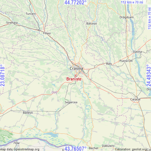
Braniște GPS coordinates[2]
44° 16' 14.52" North, 23° 47' 25.08" East
| Map corner | latitude | longitude |
|---|---|---|
| Upper-left | 44.77202°, | 23.08718° |
| Center: | 44.2707°, | 23.7903° |
| Lower-right: | 43.76507°, | 24.49343° |
| Map W x H: | 112×112 km | = 69.6×69.6mi |
| max Lat: | 48.23793° ⇑91.5% North |
| Braniște: | 44.2707° |
| min Lat: | ⇓8.5% South 43.65638° |
| min Long | Braniște | max Long |
| 20.31667° | 23.7903° | 29.65403° |
| W 27.3%⇐ | ⇒72.7% E |
Elevation
Elevation of Braniște is 71 m = 233 ft, and this is 183.9 m = 603 ft below average elevation for this country.
| Max E: |
1278 m = 4193 ft | 87% |
| Avg. | 254.9 m = 836 ft | |
| Braniște | 71 m = 233 ft | |
Min E: |
-2 m = -7 ft | 13% |
See also: Romania elevation on elevation.city.
Geographical zone
Braniște is located in North temperate zone (between Tropic of Cancer and the Arctic Circle). Distance of this Northern Tropic circle is 2316.5 km =1439.4 mi to South.| Distance of | km | miles | from Braniște |
|---|---|---|---|
| North Pole | 5084.6 | 3159.4 | to North |
| Arctic Circle | 2478.7 | 1540.2 | to North |
| Tropic Cancer | 2316.5 | 1439.4 | to South |
| Equator | 4922.4 | 3058.6 | to South |


Nearby cities:
15 places around Braniște: (largest is in red/bold)
• Bucovăţ
4.6 km =2.9 mi,  315°
315°
• Cernele
8 km =5 mi,  330°
330°
• Cernelele de Sus
8.5 km =5.3 mi, 331°
• Craiova
5.2 km =3.2 mi,  8°
8°
• Cârcea
8.7 km =5.4 mi,  91°
91°
• Făcăi
2.4 km =1.5 mi,  82°
82°
• Izvorul Rece
9.9 km =6.2 mi,  342°
342°
• Livezi
4.4 km =2.7 mi,  180°
180°
• Malu Mare
6 km =3.7 mi,  122°
122°
• Mofleni
4.3 km =2.7 mi, 324°
• Palilula
5.5 km =3.4 mi,  268°
268°
• Podari
2.4 km =1.5 mi,  193°
193°
• Popoveni
2 km =1.2 mi, 341°
• Preajba
4.8 km =3 mi,  97°
97°
• Ţuglui
9.9 km =6.2 mi,  167°
167°
Sources, notices
• [Note1] Compared only with cities in Romania existing in our database
• [Src1] Map data: © OpenStreetMap contributors (CC-BY-SA)
• [Src2] Other city data from geonames.org with taken over terms of usage.
• [Src3] Geographical zone / Annual Mean Temperature by Robert A. Rohde @ Wikipedia
