Ciuperceni geodata
Ciuperceni (Gorj) is a seat of a second-order administrative division; located in Romania in Europe/Bucharest (GMT+3) time zone. With population of 1,735 people, there are 2892 cities with bigger population in this country. Compared to other cities in Romania, 72.2% of cities are located further ↑North; 84.2% of cities are located further →East and 55.2% of cities have higher elevation than Ciuperceni. Note1


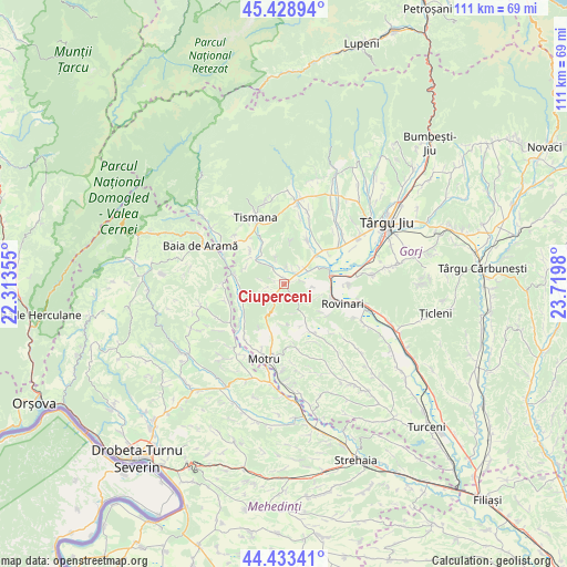
Ciuperceni GPS coordinates[2]
44° 55' 59.988" North, 23° 1' 0.012" East
| Map corner | latitude | longitude |
|---|---|---|
| Upper-left | 45.42894°, | 22.31355° |
| Center: | 44.93333°, | 23.01667° |
| Lower-right: | 44.43341°, | 23.7198° |
| Map W x H: | 110.7×110.7 km | = 68.8×68.8mi |
| max Lat: | 48.23793° ⇑72.2% North |
| Ciuperceni: | 44.93333° |
| min Lat: | ⇓27.8% South 43.65638° |
| min Long | Ciuperceni | max Long |
| 20.31667° | 23.01667° | 29.65403° |
| W 15.8%⇐ | ⇒84.2% E |
Elevation
Elevation of Ciuperceni is 186 m = 610 ft, and this is 68.9 m = 226 ft below average elevation for this country.
| Max E: |
1278 m = 4193 ft | 55.2% |
| Avg. | 254.9 m = 836 ft | |
| Ciuperceni | 186 m = 610 ft | |
Min E: |
-2 m = -7 ft | 44.8% |
See also: Romania elevation on elevation.city.
Geographical zone
Ciuperceni is located in North temperate zone (between Tropic of Cancer and the Arctic Circle). Distance of this Northern Tropic circle is 2390.2 km =1485.2 mi to South.| Distance of | km | miles | from Ciuperceni |
|---|---|---|---|
| North Pole | 5010.9 | 3113.6 | to North |
| Arctic Circle | 2405.1 | 1494.5 | to North |
| Tropic Cancer | 2390.2 | 1485.2 | to South |
| Equator | 4996.1 | 3104.4 | to South |


Nearby cities:
15 places around Ciuperceni: (largest is in red/bold)
• Brădet
8.6 km =5.3 mi,  149°
149°
• Buduhala
10.5 km =6.5 mi,  57°
57°
• Celei
11.2 km =7 mi,  320°
320°
• Câlnic
5.6 km =3.5 mi,  70°
70°
• Câlnicu de Sus
3.1 km =1.9 mi,  37°
37°
• Glogova
8.7 km =5.4 mi,  266°
266°
• Godineşti
8.4 km =5.2 mi,  332°
332°
• Mătăsari
10.6 km =6.6 mi, 150°
• Olteanu
9.3 km =5.8 mi,  235°
235°
• Pinoasa
7 km =4.3 mi,  113°
113°
• Roșiuța
8.9 km =5.5 mi,  198°
198°
• Runcurel
8.3 km =5.2 mi,  178°
178°
• Teleşti
9.1 km =5.7 mi, 35°
• Vârț
9.4 km =5.8 mi,  78°
78°
• Șomănești
8.3 km =5.2 mi, 68°
Sources, notices
• [Note1] Compared only with cities in Romania existing in our database
• [Src1] Map data: © OpenStreetMap contributors (CC-BY-SA)
• [Src2] Other city data from geonames.org with taken over terms of usage.
• [Src3] Geographical zone / Annual Mean Temperature by Robert A. Rohde @ Wikipedia
