Câlnicu de Sus geodata
Câlnicu de Sus (Gorj) is a populated place; located in Romania in Europe/Bucharest (GMT+3) time zone. With population of 593 people, there are 6250 cities with bigger population in this country. Compared to other cities in Romania, 71.3% of cities are located further ↑North; 83.9% of cities are located further →East and 58.1% of cities have higher elevation than Câlnicu de Sus. Note1


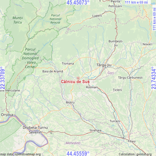
Câlnicu de Sus GPS coordinates[2]
44° 57' 19.152" North, 23° 2' 24.756" East
| Map corner | latitude | longitude |
|---|---|---|
| Upper-left | 45.45073°, | 22.33709° |
| Center: | 44.95532°, | 23.04021° |
| Lower-right: | 44.45559°, | 23.74334° |
| Map W x H: | 110.6×110.6 km | = 68.7×68.7mi |
| max Lat: | 48.23793° ⇑71.3% North |
| Câlnicu de Sus: | 44.95532° |
| min Lat: | ⇓28.7% South 43.65638° |
| min Long | Câlnicu de Sus | max Long |
| 20.31667° | 23.04021° | 29.65403° |
| W 16.1%⇐ | ⇒83.9% E |
Elevation
Elevation of Câlnicu de Sus is 173 m = 568 ft, and this is 81.9 m = 269 ft below average elevation for this country.
| Max E: |
1278 m = 4193 ft | 58.1% |
| Avg. | 254.9 m = 836 ft | |
| Câlnicu de Sus | 173 m = 568 ft | |
Min E: |
-2 m = -7 ft | 41.9% |
See also: Romania elevation on elevation.city.
Geographical zone
Câlnicu de Sus is located in North temperate zone (between Tropic of Cancer and the Arctic Circle). Distance of this Northern Tropic circle is 2392.6 km =1486.7 mi to South.| Distance of | km | miles | from Câlnicu de Sus |
|---|---|---|---|
| North Pole | 5008.5 | 3112.1 | to North |
| Arctic Circle | 2402.6 | 1492.9 | to North |
| Tropic Cancer | 2392.6 | 1486.7 | to South |
| Equator | 4998.6 | 3106 | to South |


Nearby cities:
15 places around Câlnicu de Sus: (largest is in red/bold)
• Brădet
10.1 km =6.3 mi,  165°
165°
• Brădiceni
11.8 km =7.3 mi,  14°
14°
• Buduhala
7.7 km =4.8 mi,  65°
65°
• Celei
10.9 km =6.8 mi,  304°
304°
• Ciuperceni
3.1 km =1.9 mi,  217°
217°
• Câlnic
3.4 km =2.1 mi,  99°
99°
• Glogova
10.9 km =6.8 mi,  253°
253°
• Godineşti
7.6 km =4.7 mi,  310°
310°
• Pinoasa
7 km =4.3 mi,  139°
139°
• Roșiuța
11.8 km =7.3 mi,  203°
203°
• Runcurel
10.8 km =6.7 mi,  188°
188°
• Teleşti
6 km =3.7 mi,  34°
34°
• Tismana
12 km =7.5 mi,  331°
331°
• Vârț
7.4 km =4.6 mi,  94°
94°
• Șomănești
5.8 km =3.6 mi,  83°
83°
Sources, notices
• [Note1] Compared only with cities in Romania existing in our database
• [Src1] Map data: © OpenStreetMap contributors (CC-BY-SA)
• [Src2] Other city data from geonames.org with taken over terms of usage.
• [Src3] Geographical zone / Annual Mean Temperature by Robert A. Rohde @ Wikipedia
