Pinoasa geodata
Pinoasa (Gorj) is a populated place; located in Romania in Europe/Bucharest (GMT+3) time zone. With population of 585 people, there are 6325 cities with bigger population in this country. Compared to other cities in Romania, 72.7% of cities are located further ↑North; 83.1% of cities are located further →East and 55.6% of cities have higher elevation than Pinoasa. Note1


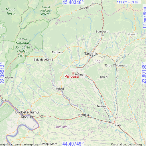
Pinoasa GPS coordinates[2]
44° 54' 27.468" North, 23° 5' 53.7" East
| Map corner | latitude | longitude |
|---|---|---|
| Upper-left | 45.40346°, | 22.39513° |
| Center: | 44.90763°, | 23.09825° |
| Lower-right: | 44.40749°, | 23.80138° |
| Map W x H: | 110.7×110.7 km | = 68.8×68.8mi |
| max Lat: | 48.23793° ⇑72.7% North |
| Pinoasa: | 44.90763° |
| min Lat: | ⇓27.3% South 43.65638° |
| min Long | Pinoasa | max Long |
| 20.31667° | 23.09825° | 29.65403° |
| W 16.9%⇐ | ⇒83.1% E |
Elevation
Elevation of Pinoasa is 184 m = 604 ft, and this is 70.9 m = 233 ft below average elevation for this country.
| Max E: |
1278 m = 4193 ft | 55.6% |
| Avg. | 254.9 m = 836 ft | |
| Pinoasa | 184 m = 604 ft | |
Min E: |
-2 m = -7 ft | 44.4% |
See also: Romania elevation on elevation.city.
Geographical zone
Pinoasa is located in North temperate zone (between Tropic of Cancer and the Arctic Circle). Distance of this Northern Tropic circle is 2387.3 km =1483.4 mi to South.| Distance of | km | miles | from Pinoasa |
|---|---|---|---|
| North Pole | 5013.8 | 3115.4 | to North |
| Arctic Circle | 2407.9 | 1496.2 | to North |
| Tropic Cancer | 2387.3 | 1483.4 | to South |
| Equator | 4993.3 | 3102.7 | to South |


Nearby cities:
15 places around Pinoasa: (largest is in red/bold)
• Brădet
5 km =3.1 mi,  204°
204°
• Buduhala
8.9 km =5.5 mi,  15°
15°
• Ciuperceni
7 km =4.3 mi,  293°
293°
• Croici
8.5 km =5.3 mi,  180°
180°
• Câlnic
4.9 km =3 mi,  346°
346°
• Câlnicu de Sus
7 km =4.3 mi,  319°
319°
• Fărcăşeşti
9.2 km =5.7 mi,  119°
119°
• Moi
8.7 km =5.4 mi,  94°
94°
• Mătăsari
6.5 km =4 mi,  190°
190°
• Negomir
9.9 km =6.2 mi,  146°
146°
• Rovinari
6.8 km =4.2 mi,  81°
81°
• Roșia Jiu
5.4 km =3.4 mi,  111°
111°
• Runcurel
8.2 km =5.1 mi,  228°
228°
• Vârț
5.5 km =3.4 mi,  30°
30°
• Șomănești
6.1 km =3.8 mi,  11°
11°
Sources, notices
• [Note1] Compared only with cities in Romania existing in our database
• [Src1] Map data: © OpenStreetMap contributors (CC-BY-SA)
• [Src2] Other city data from geonames.org with taken over terms of usage.
• [Src3] Geographical zone / Annual Mean Temperature by Robert A. Rohde @ Wikipedia
