Ciuguzel geodata
Ciuguzel (Alba) is a populated place; located in Romania in Europe/Bucharest (GMT+3) time zone. With population of 749 people, there are 5290 cities with bigger population in this country. Compared to other cities in Romania, 61.8% of cities are located further ↓South; 71.7% of cities are located further →East and 69.1% of cities have lower elevation than Ciuguzel. Note1


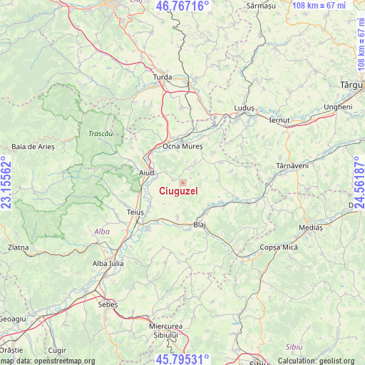
Ciuguzel GPS coordinates[2]
46° 17' 0.204" North, 23° 51' 31.464" East
| Map corner | latitude | longitude |
|---|---|---|
| Upper-left | 46.76716°, | 23.15562° |
| Center: | 46.28339°, | 23.85874° |
| Lower-right: | 45.79531°, | 24.56187° |
| Map W x H: | 108.1×108.1 km | = 67.2×67.2mi |
| max Lat: | 48.23793° ⇑38.2% North |
| Ciuguzel: | 46.28339° |
| min Lat: | ⇓61.8% South 43.65638° |
| min Long | Ciuguzel | max Long |
| 20.31667° | 23.85874° | 29.65403° |
| W 28.3%⇐ | ⇒71.7% E |
Elevation
Elevation of Ciuguzel is 313 m = 1027 ft, and this is 58.1 m = 191 ft above average elevation for this country.
| Max E: |
1278 m = 4193 ft | 30.9% |
| Ciuguzel | 313 m 1027 ft | |
| Avg. | 254.9 m = 836 ft | |
Min E: |
-2 m = -7 ft | 69.1% |
See also: Romania elevation on elevation.city.
Geographical zone
Ciuguzel is located in North temperate zone (between Tropic of Cancer and the Arctic Circle). Distance of this North polar circle is 2254.9 km =1401.1 mi to North.| Distance of | km | miles | from Ciuguzel |
|---|---|---|---|
| North Pole | 4860.8 | 3020.4 | to North |
| Arctic Circle | 2254.9 | 1401.1 | to North |
| Tropic Cancer | 2540.3 | 1578.5 | to South |
| Equator | 5146.2 | 3197.7 | to South |


Nearby cities:
15 places around Ciuguzel: (largest is in red/bold)
• Aiud
11 km =6.8 mi,  285°
285°
• Beța
4.7 km =2.9 mi,  225°
225°
• Bucerdea-Grânoasă
9.5 km =5.9 mi,  191°
191°
• Băgău
5.8 km =3.6 mi,  301°
301°
• Cisteiu de Mureș
11 km =6.8 mi,  341°
341°
• Ciumbrud
7.9 km =4.9 mi, 290°
• Crăciunelu de Jos
11.3 km =7 mi, 189°
• Hopârta
4.3 km =2.7 mi,  14°
14°
• Lopadea Nouă
3.2 km =2 mi, 285°
• Ocna Mureş
11.1 km =6.9 mi,  356°
356°
• Pănade
10.1 km =6.3 mi,  130°
130°
• Rădeşti
11.1 km =6.9 mi,  260°
260°
• Sâncel
11.6 km =7.2 mi,  142°
142°
• Sâncrai
8.3 km =5.2 mi,  278°
278°
• Uioara de Jos
9.8 km =6.1 mi,  350°
350°
Sources, notices
• [Note1] Compared only with cities in Romania existing in our database
• [Src1] Map data: © OpenStreetMap contributors (CC-BY-SA)
• [Src2] Other city data from geonames.org with taken over terms of usage.
• [Src3] Geographical zone / Annual Mean Temperature by Robert A. Rohde @ Wikipedia
